
Range Blue Mountains | Elevation 1,000 m | |
 | ||
Similar Blue Mountains, Mount Solitary, Jamison Valley, Ruined Castle, Kings Tableland | ||
Allie pepper abseiling on narrow neck plateau in katoomba
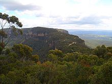
The Narrow Neck Plateau, an eroded remnant of a sandstone layer situated at an elevation of 1,000 metres (3,300 ft) above sea level that is part of the Blue Mountains Range which is a spur line off the Great Dividing Range, is situated immediately south-west of Katoomba in New South Wales, Australia, located within the Blue Mountains National Park. The neck separates the Jamison Valley (to the east) from the Megalong Valley (to the west).
Contents
- Allie pepper abseiling on narrow neck plateau in katoomba
- Map of Narrow Neck Plateau Blue Mountains National Park NSW 2787 Australia
- Narrow neck plateau katoomba n s w
- Description
- Missing person
- Fauna
- Points of Interest
- References
Map of Narrow Neck Plateau, Blue Mountains National Park NSW 2787, Australia
Narrow neck plateau katoomba n s w
Description
From Cliff Drive, Katoomba, the Narrow Neck is accessed via a dirt road called Glenraphael Drive suitable for most two-wheel drive vehicles, subject to good weather conditions, as far as a locked gate. It is a popular walking, bike riding and climbing location and offers several walking descent routes to the adjacent valleys. Beyond the gate is walking/bicycle access only for the general public. One of the most popular walks is the Golden Stairs, a rough descent of approximately 200 metres (660 ft) to join the Federal Pass. This opens up the Jamison Valley for popular day walks to sites such as Mount Solitary and the Ruined Castle. The neck juts southwards from Katoomba for a distance of some 10 kilometres (6.2 mi) and ends at Clear Hill, overlooking the Wild Dog Mountains. Castle Head promontory points towards the Ruined Castle, a small rock formation between Castle Head and Mount Solitary. Arguably one of the best views on the eastern seaboard of NSW is from Narrow Neck Fire Tower. On a day of high visibility it is possible to see from Mittagong in the south to Toronto in the north and a number of peak landforms in between. It also has excellent views back towards the escarpment at Katoomba.
Missing person
A nineteen-year-old British backpacker Jamie Neale was found after twelve days lost in the Blue Mountains. Two bushwalkers alerted emergency services who were conducting an extensive search using the Police Rescue Squad, police dogs, State Emergency Service and Rural Fire Service.
Fauna
Upland swamps on Narrow Neck Plateau have been identified as potential habitats for the rare Blue Mountain Water Skink.