
Area rank Ranked 14th Postal code 54000-56999 Area 24,598 km² Population 1.164 million (2015) | Time zone EET (UTC+2) Area code +380-51 Founded 22 September 1937 | |
 | ||
Points of interest Southern Bug, Mykolaev Zoo, Water Park Kobleve, Strategic missile forces mu, The Fairytale Colleges and Universities Admiral Makarov National, Petro Mohyla Black Se, Mykolayiv State Agrarian, Nikolaevskiy stroitelnyy kolledzh | ||
Mykolaiv Oblast (Russian: Николаевская область, Mykolajivśka oblasť; Ukrainian: Миколаївська область, Mykolajivśka oblasť'; also referred to as Mykolayivshchyna - Ukrainian: Миколаївщина) is an oblast (province) of Ukraine. The administrative center of the oblast is the city of Mykolaiv. Population: 1,164,342 (2015 est.)
Contents
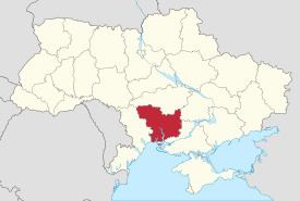
- Map of Mykolaivska oblast Ukraine
- Geography
- Points of interest
- Demographics
- Age structure
- Median age
- Administrative divisions
- Public opinion
- References
Map of Mykolaivs'ka oblast, Ukraine
Geography
The Mykolaiv Oblast is located in the southern half of Ukraine. Its area (24,600 km²), comprises about 4.07% of the total area of Ukraine.
The Mykolaiv Oblast borders upon the Odessa Oblast in the west-southwest, the Kirovohrad Oblast in the north, the Dnipropetrovsk Oblast in the northeast, and the Kherson Oblast on the southeast.
To the south the oblast is also bordered by the Black Sea. Along the coast there are several ports and the Mykolaiv International Airport.
Points of interest
The following historic-cultural sites were nominated for the Seven Wonders of Ukraine or Seven Natural Wonders of Ukraine.
Demographics
The current estimated population is 1.2 million people (as of 2005). The greater part of the oblast's population resides in urban type settlements (66%), with the remainder residing in agricultural areas. Also, almost 60% of the urban population resides in Mykolayiv, the industrial, cultural and administrative center of Mykolayiv Oblast.
The oblast's population density is one of the lowest in Ukraine – 52 people per 1 km². The oblast' is ranked 18 by the percentage of the population of Ukraine, that the Mykolaiv Oblast contain, which is 2.6%.
Age structure
0-14 years: 14.7% (male 88,668/female 83,434)15-64 years: 70.7% (male 396,342/female 432,808)65 years and over: 14.6% (male 56,527/female 114,987) (2013 official)Median age
total: 39.7 years male: 36.3 years female: 42.9 years (2013 official)Administrative divisions
Mykolaiv Oblast formed in September 1937. It is subdivided into 19 raions (administrative districts), and 4 municipalities (misto) which are directly subordinate to the oblast government.
Note: Asterisks (*) Though the administrative center of the rayon is housed in the city/town that its named after, cities do not answer to the rayon authorities only towns do; instead they are directly subordinated to the oblast government and therefore are not counted as part of rayon statistics.At a lower level of administration, these district-level administrations are subdivided into:
The local administration of the oblast is controlled by the Mykolaiv Oblast Rada. The governor of the oblast is the Mykolaiv Oblast Rada speaker, appointed by the President of Ukraine.
Public opinion
During the 1991 referendum, 89.45% of votes in Mykolaiv Oblast were in favor of the Declaration of Independence of Ukraine. A survey conducted in December 2014 by the Kyiv International Institute of Sociology found 2.1% of the oblast's population supported their region joining Russia, 95.5% did not support the idea, and the rest were undecided or did not respond.