
Website Official website | Major highways NH 58 , SH -12 Area 4,008 km² | |
 | ||
Muzaffarnagar district is a district of Uttar Pradesh state in northern India. It is part of Saharanpur division. The city of Muzaffarnagar is the district headquarters. This district is also the part of National Capital Region.
Contents
- Map of Muzaffarnagar Uttar Pradesh
- Medieval period
- Modern era
- 2013 Muzaffarnagar riots
- Blocks
- Demographics
- Education
- References
Map of Muzaffarnagar, Uttar Pradesh
Medieval period
Muzaffarnagar's early medieval history is obscure till the Indo-Mughal period. Timur's army had marched to Delhi through this region in 1399; its people fought it unsuccessfully. In Mughal Emperor Akbar's time, most of the Muzaffarnagar district region, called Sarwat then under the Mahal control of Taga / Tyagi brahmans of Sarvat village, belonged to the sarkar (circle) of Saharanpur. Akbar bestowed pargana of Sarwat on Sayyed Mahmud Khan Barha which remained with his descendants up to the 17th century. After killing Peer Khan Lodi styled as Khan Jahan lodi, Shahjahan bestowed title of deceased Peer Khan Lodhi and Pargana of Sarwat on Sayyed Muzaffar Khan Barha, whose son Munawwar Lashkar Khan Barha established the city and named it Muzaffarnagar in honour of his father, and Sarwat also became Muzaffarnagar.
Modern era
Muzaffarnagar district gained notoriety in the 20th century with frequent incidents of loot, murders, kidnappings and dacoity.
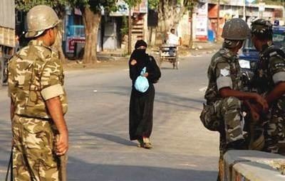
2013 Muzaffarnagar riots
The 2013 Muzaffarnagar riots between Hindus and Muslims resulted in 62 deaths. According to a May 2015 report in India Today:
Shamli and adjoining Muzaffarnagar districts are considered sensitive ever since large-scale communal violence erupted in August and September 2013. More than 50 people had died and over 50,000 were rendered homeless...The riot that ensued had engulfed many districts of western UP.
Blocks
The district is divided into 9 blocks, these are:
Demographics
According to the 2011 census Muzaffarnagar district has a population of 2,827,154, roughly equal to the nation of Lebanon or the US state of Oregon. This gives it a ranking of 125th in India (out of a total of 640). The district has a population density of 960 inhabitants per square kilometre (2,500/sq mi) . Its population growth rate over the decade 2001-2011 was 16.8%. Muzaffarnagar has a sex ratio of 886 females for every 1000 males, and a literacy rate of 70.11%. Minority population is about 40% of the total population of the district Muzaffarnagar is a category "B1" district i.e. having socio-economic parameters below the national average.
Education
There are two medical colleges and five engineering colleges in this district. There are four management colleges and eight degree colleges in the city.