
1872–1917 → 1897 298,653 | Established 1872 | |
 | ||
1862 12,486 km (4,821 sq mi) | ||
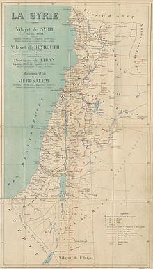
The Mutasarrifate of Jerusalem (Ottoman Turkish: Kudüs-i Şerif Mutasarrıflığı; Arabic: متصرفية القدس الشريف), also known as the Sanjak of Jerusalem, was an Ottoman district with special administrative status established in 1872. The district encompassed Jerusalem as well as Bethlehem, Hebron, Jaffa, Gaza and Beersheba. During the late Ottoman period, the Mutasarrifate of Jerusalem, together with the Sanjak of Nablus and Sanjak of Akka (Acre), formed the region that was commonly referred to as "Southern Syria" or "Palestine".
Contents
- History
- Boundaries
- Administrative divisions
- Mutasarrfs of Jerusalem
- Pre separation from Damascus
- Post separation from Damascus
- Post Young Turk Revolution
- References
The district was separated from Damascus and placed directly under Constantinople in 1841, and formally created as an independent province in 1872 by Grand Vizier Mahmud Nedim Pasha. Scholars provide a variety of reasons for the separation, including increased European interest in the region, and strengthening of the southern border of the Empire against the Khedivate of Egypt. Initially, the Mutasarrifate of Acre and Mutasarrifate of Nablus were combined with the province of Jerusalem, with the combined province being referred to in the register of the court of Jerusalem as the "Jerusalem Eyalet", and referred to by the British consul as creation of "Palestine into a separate eyalet". However, after less than two months, the sanjaks of Nablus and Acre were separated and added to the Vilayet of Beirut, leaving just the Mutasarrifate of Jerusalem. In 1906, the Kaza of Nazareth was added to the Jerusalem Mutasarrifate, as an exclave, primarily in order to allow the issuance of a single tourist permit to Christian travellers. The area was conquered by the Allied Forces in 1917 during World War I and a military Occupied Enemy Territory Administration (OETA South) set up to replace the Ottoman administration. OETA South consisted of the Ottoman sanjaks of Jerusalem, Nablus and Acre. The military administration was replaced by a British civilian administration in 1920 and the area of OETA South was incorporated into the British Mandate of Palestine in 1923.
The political status of the Mutasarrifate of Jerusalem was unique to other Ottoman province since it came under the direct authority of the Ottoman capital Constantinople. The inhabitants identified themselves primarily on religious terms. The district's villages were normally inhabited by farmers while its towns were populated by merchants, artisans, landowners and money-lenders. The elite consisted of the religious leadership, wealthy landlords and high-ranking civil servants.
History
In 1841, the district was separated from Damascus and placed directly under Constantinople and formally created as an independent Mutasarrifate in 1872. Before 1872, the Mutasarrifate of Jerusalem was officially a sanjak within the Syria Vilayet (created in 1864, following the Tanzimat reforms).
The southern border of the Mutasarifate of Jerusalem was redrawn in 1906, at the instigation of the British, who were interested in safeguarding their imperial interests and in making the border as short and patrollable as possible.
Towards the end of the 19th century, the idea that the region of Palestine or the Mutasarifate of Jerusalem formed a separate political entity became widespread among the district's educated Arab classes. In 1904, former Jerusalem official Najib Azuri formed in Paris, France the Ligue de la Patrie Arabe ("Arab Fatherland League") whose goal was to free Ottoman Syria and Iraq from Turkish domination. In 1908, Azuri proposed the elevation of the mutassarifate to the status of vilayet to the Ottoman Parliament after the 1908 Young Turk Revolution.
The area was conquered by the Allied Forces in 1917 during World War I and a military Occupied Enemy Territory Administration (OETA South) set up to replace the Ottoman administration. OETA South consisted of the Ottoman sanjaks of Jerusalem, Nablus and Acre. The military administration was replaced by a British civilian administration in 1920 and the area of OETA South became the territory of the British Mandate of Palestine in 1923, with some border adjustments with Lebanon and Syria.
Boundaries
Below are six contemporary Ottoman maps showing the "Quds Al-Sharif Sancağı" or "Quds Al-Sharif Mutasarrıflığı". The fourth map shows the 1860 borders between Ottoman Syria and the Khedivate of Egypt, although the border was moved to the current Israel-Egypt border in 1906, and the area north of the Negev Desert is labelled "Filastin" (Palestine).
The division was bounded on the west by the Mediterranean, on the east by the River Jordan and the Dead Sea, on the north by a line from the mouth of the river Auja to the bridge over the Jordan near Jericho, and on the south by a line from midway between Gaza and Arish to Aqaba.
Administrative divisions
Administrative divisions of the Mutasarrifate (1872-1909):
- Beersheba Kaza (Ottoman Turkish: قضا بءرالسبع; Turkish: Birüsseb' kazası; Arabic: قضاء بئر السبع), which included two sub-districts and a municipality:
- a-Hafir (Ottoman Turkish: ناحيه حفير; Turkish: Hafır nahiyesı; Arabic: ناحية عوجة الحفير), created in 1908 as a middle point between Beersheba and Aqaba, close to the newly agreed border with Sinai
- al-Mulayha, created in 1908 as a midway point between Hafir and Aqaba
- Beersheba (Ottoman Turkish: بلدية بءرالسبع; Turkish: Birüsseb' belediyesı; Arabic: بلدية بئر السبع), created in 1901
- Gaza Kaza (Ottoman Turkish: قضا غزّه; Turkish: Gazze kazası ; Arabic: قضاء غزة), which included three sub-districts and a municipality:
- Al-Faluja (Ottoman Turkish: ناحيه فلوجه; Turkish: Felluce nahiyesı; Arabic: ناحية الفالوجة), created in 1903
- Khan Yunis (Ottoman Turkish: ناحيه خان يونس; Turkish: Hanyunus nahiyesı; Arabic: ناحية خان يونس), created in 1903 and became a municipality in 1917
- al-Majdal (Ottoman Turkish: ... ناحيه; Turkish: Mücdel nahiyesı; Arabic: ناحية المجدل), created in 1880
- Gaza (Ottoman Turkish: بلدية غزّه; Turkish: Gazze belediyesı ; Arabic: بلدية غزة), created in 1893
- Hebron Kaza (Ottoman Turkish: قضا خليل الرحمن; Turkish: Halilü'r Rahman kazası; Arabic: قضاء الخليل), which included two sub-districts and a municipality:
- Bayt 'Itab (Ottoman Turkish: ناحيه بيت اعطاب; Turkish: Beyt-i a'tâb nahiyesı; Arabic: ناحية بيت عطاب), created in 1903
- Bayt Jibrin (Ottoman Turkish: ناحيه بيت جبرين; Turkish: Beyt-i Cireyn nahiyesı; Arabic: ناحية بيت جبرين), created in 1903
- Hebron (Ottoman Turkish: بلدية خليل الرحمن; Turkish: Halilü'r Rahman belediyesı; Arabic: بلدية الخليل), created in 1886
- Jaffa Kaza (Ottoman Turkish: قضا يافه; Turkish: Yafa kazası ; Arabic: قضاء يَافَا), which included two sub-districts and a municipality:
- Ni'lin (Ottoman Turkish: ناحيه نعلين; Turkish: Na’leyn nahiyesı; Arabic: ناحية نعلين),created in 1903
- Ramla (Ottoman Turkish: ناحيه رمله; Turkish: Remle nahiyesı; Arabic: ناحية الرملة), created in 1880, became municipality before 1888 and re-established as sub-district in 1889
- Lydda (Ottoman Turkish: ... بلدية; Turkish: Lod belediyesı ; Arabic: ... بلدية)
- Jerusalem Kaza (Ottoman Turkish: قضا قدس; Turkish: Kudüs-i Şerif kazası; Arabic: قضاء القدس الشريف), which included four sub-districts and two municipalities:
- Abwein (Ottoman Turkish: ... ناحيه; Turkish: Abaveyn nahiyesı; Arabic: ناحية عبوين), created in 1903;
- Bethlehem (Ottoman Turkish: ناحيه بيت اللحم; Turkish: Beytü'l lahim nahiyesı; Arabic: ناحية بيت لحم), created in 1883 and became a municipality in 1894;
- Ramallah (Ottoman Turkish: ناحيه رام الله; Turkish: Ramallah nahiyesı; Arabic: ناحية رام الله), created in 1903 and became a municipality in 1911,
- Saffa (Ottoman Turkish: ناحيه صفا; Turkish: Safa nahiyesı; Arabic: ناحية صفّا),
- Jerusalem (Ottoman Turkish: بلدية قدس; Turkish: Kudüs-i Şerif belediyesı; Arabic: بلدية القدس الشريف), created in 1867 and
- Beit Jala (Ottoman Turkish: ... بلدية; Turkish: ... belediyesı; Arabic: بلدية بيت جالا),created in 1912.
- Nazareth Kaza (Ottoman Turkish: قضا الْنَاصِرَة; Turkish: Nasra kazası; Arabic: قضاء الْنَاصِرَة), established 1906.
Mutasarrıfs of Jerusalem
The Mutasarrıfs of Jerusalem were appointed by the Porte to govern the district. They were usually experienced civil servants who spoke little or no Arabic, but knew a European language - most commonly French - in addition to Ottoman Turkish.
Pre-separation from Damascus
Post-separation from Damascus
Post Young Turk Revolution
List of mutasarrıfs after the 1908 Young Turk Revolution: