
Pronunciation [tsu͍bakuɽodake] | Elevation 2,763 m Easiest route Hiking | |
 | ||
Topo map Geospatial Information Authority 25000:1 槍ヶ岳50000:1 槍ヶ岳 Similar Mt Otensho, Mount Jōnen, Mount Yari, Mount Hotakadake, Mt Gaki | ||
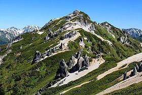
Mount Tsubakuro (燕岳, Tsubakuro-dake) is a 2,763 metres (9,065 ft) high mountain in Azumino, Nagano Prefecture, Japan. It is situated in Japan's Hida Mountains in Nagano Prefecture. It was specified for Chūbu-Sangaku National Park on December 4, 1934.
Contents
- Map of Mount Tsubakuro Hotakaariake Azumino Nagano Prefecture 399 8301 Japan
- Mountain hut
- Nearby mountains
- Rivers
- References
Map of Mount Tsubakuro, Hotakaariake, Azumino, Nagano Prefecture 399-8301, Japan
Mountain hut
The mountain climbing trail between Mount Tsubakuro and Mount Yari is called Main Street (表銀座, Omote-Ginza) owing to its extensive use over time. It has two mountain huts along the way. Tsubakuro mountain cottage (燕山荘, Enzansō) is located at near the summit and is one of the oldest mountain huts in Japan, completed in 1921
Nearby mountains
The following are the main mountains in the surrounding.
Rivers
The mountain is the source of the following rivers, each of which flows to the Sea of Japan.
References
Mount Tsubakuro Wikipedia(Text) CC BY-SA