
Elevation 3,464 m Prominence 547 m | Topo map NTS 83C/05 First ascent 1897 Parent range Bow Range | |
 | ||
Easiest route South Summit, South-East Ridge II Similar Mount Lefroy, Mount Temple, Mount Whyte, Fairview Mountain, Mount Hungabee | ||
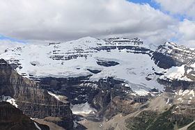
Mount Victoria, 3,464 metres (11,365 ft), is a mountain on the border between British Columbia and Alberta in the Canadian Rockies. It is located just northeast of Lake O'Hara in Yoho National Park and is also part of Banff National Park and is on the Continental Divide (which is the definition of the interprovincial boundary in this region).
Map of Mount Victoria North Peak, Columbia-Shuswap A, BC, Canada
The mountain is located on the western buttress of Abbot Pass while Mount Lefroy lies on the eastern side.
The mountain was named by J. Norman Collie in 1897 for Queen Victoria.
References
Mount Victoria (Bow Range) Wikipedia(Text) CC BY-SA