
Parent range Sierra Nevada Easiest route Scramble, class 2 Prominence 343 m | Elevation 4,275 m Mountain range Sierra Nevada | |
 | ||
Similar Mount Williamson, Middle Palisade, Mount Keith, Mount Muir, Mount Barnard | ||
Mount Tyndall is a peak in the Mount Whitney region of the Sierra Nevada in the U.S. state of California. It rises to 14,025 feet (4,275 m), and is the tenth highest peak in the state. The mountain was named in honor of the Irish scientist and mountaineer, John Tyndall.
Contents
Map of Mt Tyndall, California 93526, USA
GeographyEdit
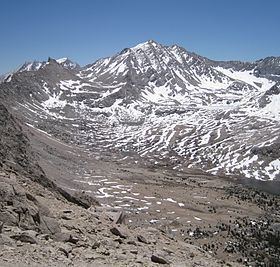
Tyndall lies on the Sierra Crest, which in this region forms the boundary between the John Muir Wilderness and the Inyo National Forest on the east, and Sequoia National Park on the west; and the boundary between Inyo and Tulare counties. Mount Tyndall is 1.5 miles (2.4 km) west of the higher Mount Williamson, and about 6 miles (9.7 km) north-northeast of Mount Whitney.
HistoryEdit
Mount Tyndall was first climbed on July 6, 1864 by Clarence King and Richard Cotter who were members of the California Geological Survey and under the overall direction of Josiah Whitney and the field leadership of William Brewer. King and Cotter were attempting to make the first ascent of Mount Whitney, and had made a long trek from Kings Canyon, only to realize months later that they had climbed the wrong peak.
Climbing routesEdit
The easiest route on Mount Tyndall in terms of access and climbing is the Northwest Ridge, which involves an easy scramble (class 2). It begins about one half mile (0.8 km.) west of Shepherd Pass and about 1 mile (1.6 km) north of the peak. Other non-technical routes exist on the gently sloped west side of the peak. At least two significant technical routes lie on the much steeper east face; the first of these routes was climbed by noted mountaineer Fred Beckey and Charlie Raymond in 1970.