
Mountain type volcanic Elevation 1,558 m | Volcanic arc/belt Kurile Arc | |
 | ||
Topo map Geographical Survey Institute 25000:1 天塩岳25000:1 宇江内山50000:1 旭川 Easiest route Hike New Trail (新道コース, Shindō Course) Similar Mount Ishikari, Mount Petegari, Nipesotsu‑Maruyama Volcanic Group, Mount Kamuiekuuchikaushi, Mount Ashibetsu | ||
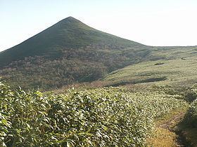
Mount Teshio (天塩岳, Teshio-dake) is the tallest mountain in the Kitami Mountains. It is located on the border of Shibetsu and Takinoue, Hokkaidō, Japan. It is the source of the Teshio River.
Contents
- Map of Mount Teshio Takinouegenya Takinoue Monbetsu District Hokkaido Prefecture 099 5600 Japan
- History
- Geology
- Flora and fauna
- Climbing routes
- References
Map of Mount Teshio, Takinouegenya, Takinoue, Monbetsu District, Hokkaido Prefecture 099-5600, Japan
History
On January 6, 1978, Mount Teshio and the surrounding region was designated the Mount Teshio Prefectural Natural Park (天塩岳道立自然公園, Teshio-dake Dōritsu Shizenkōen).
Geology
Mount Teshio is made from felsic non-alkali rock from 15 to 7 million years old.
Flora and fauna
At the base of the mountain there are abundant black woodpeckers as well as Japanese red foxes and Hokkaidō brown bears. Near the summit, pika can be found.
Prominent alpine plants are Rhododendron aureum and Diapensia lapponica.
Climbing routes
There are three climbing routes up the mountain.
There is a connecting path between the new trail and the other two trails.