
Listing Ultra Prominence 2,037 m Easiest routes Barangay, Palauig | Elevation 2,037 m Municipality Palauig Province Zambales | |
 | ||
Similar Mount Pulag, Mount Arayat, Mount Dulang‑dulang, Mount Natib, Mount Amuyao | ||
Mount Tapulao (also known as High Peak) is the tallest mountain in the Zambales Mountain range and in the province of Zambales in the Philippines. The peak, which rise to an elevation of 2,037 metres (6,683 ft), is located in the municipality of Palauig, Zambales. Its name is derived from the abundance of Sumatran Pine trees in the area, known in the local Zambal dialect as tapulao.
Contents
- Map of Mount Tapulao Palauig Zambales Philippines
- Hiking activityEdit
- From PalauigEdit
- Traverse hikeEdit
- EcosystemEdit
- References
Map of Mount Tapulao, Palauig, Zambales, Philippines
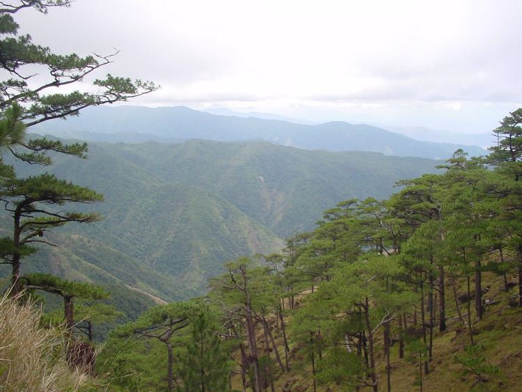
The mountain was once a site of a large-scale chromite mining operations. The destruction of the beautiful natural scenery is visible in the mine pits on the summit as well as other related structures along the trail. The summit offers a 360-degree vista from where you can see the other Zambales mountains on the eastern side, Lingayen Gulf to the north, and on the western side, the Zambales lowlands and the South China Sea stretching to as far south as Pundaquit in San Antonio, Zambales.
Hiking activityEdit
The trail to the top of Mount Tapulao is on rolling and gradual terrain that takes hikers through a number of distinct ecosystems: from lowland grass and scrubland dominated by talahib (cogon grass) to its flanks of secondary to primary dipterocarp forest, mossy montane forest and pine forest above 1,800 metres (5,900 ft) that extends to the adjacent mountains.
During wet weather, limatik or forest leeches abound especially near the streams along the way. Parts of the trail become rivulets that trekkers easily attracts these critters without noticing being bitten, sticking on the human skin.
From PalauigEdit
Mount Tapulao can be reached by trekking the mining road on a ridge on the side of the mountain with the forest line starting at about 1,875 metres (6,152 ft). The jump-off point is from the Dampay resettlement area in Brgy. Salaza in Palauig, which is around 8 kilometres (5.0 mi) from the Zambales Regional Highway on rough road. From the trailhead at Brgy. Dampay to the summit is around 18 kilometres (11 mi). Residents of Dampay are evacuees from the foot of Mount Pinatubo and are the "self-appointed guardians" of Mt. Tapulao under the coordination of the Municipal Tourism Authority of Palauig, Zambales.
The ascent can be done in 7–8 hours while the descent can be covered in half the time. Guest and tourist aiming to climb the mountain are required to register at the barangay hall to receive further safety, security and cooperation according to the rule and guidance of the tourism authority. Farther down the settlement is a trail leading to the jump off-point for the Bagsit River whitewater river rafting.
Traverse hikeEdit
A traverse hike is also possible starting from the eastern side of the Mount Tapulao in Brgy. Labney in the town of Mayantoc in Tarlac province, ending in Palauig, or vice versa. The trail from the northwest is longer and a much more challenging route than the one from Zambales, but the reward is a more diverse environment and fauna.