
Topo map USGS Melvin Village Prominence 710 m | Elevation 911 m | |
 | ||
Listing #23 New England Fifty Finest Similar Mount Roberts, Turtleback Mountain, Bayle Mountain, Belknap Mountain, Nickerson Mountain | ||
Mount shaw black snout nh
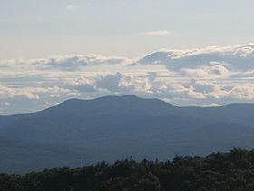
Mount Shaw is a mountain located in the towns of Moultonborough and Tuftonboro in Carroll County, New Hampshire, United States. It is part of the remains of an ancient volcanic ring dike. With a summit elevation of 2,990 feet (911 m), it is the highest of the Ossipee Mountains.
Contents
Map of Mt Shaw, Moultonborough, NH 03254, USA
The Ossipee ring-dike complex of central New Hampshire is a visible remnant of a Cretaceous stratovolcano, ca. 125 Ma, a member of the later White Mountain igneous province. The complex is circular as viewed on maps and has a diameter of 9 miles (14 km). The ring-dike complex is easy to identify within web-browsed satellite images, the southeast edge located about 5 miles (8 km) northwest of the town center of Ossipee.
Although of only moderate elevation, the isolation of the mountain range gives Shaw 2,330 ft (710 m) of prominence above the low ground separating it from the White Mountains, making it one of twelve peaks in New Hampshire with a prominence over 2,000 feet (610 m).
Mount Shaw is located within the Castle in the Clouds estate. Its north and southeast sides drain into the Lovell and Dan Hole rivers, thence into the Ossipee River, Saco River and the Gulf of Maine. The southwest side drains into the Melvin River which flows into Lake Winnipesaukee, thence into the Winnipesaukee River, Merrimack River, and into the Gulf of Maine in Massachusetts.