
Max. length 20.8 mi (33.5 km) Area 183.9 km² Surface elevation 154 m | Basin countries United States Max. width 9.0 mi (14.5 km) Length 33.4 km | |
 | ||
Primary inflows Fish Common carp, Texas cichlid, Grass carp, Rainbow trout Similar | ||
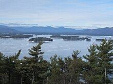
Chillin at lake winnipesaukee new hampshire usa
Lake Winnipesaukee (/ˌwɪnɪpəˈsɔːki/) is the largest lake in the U.S. state of New Hampshire, located in the Lakes Region. It is approximately 21 miles (34 km) long (northwest-southeast) and from 1 to 9 miles (1.6 to 14.5 km) wide (northeast-southwest), covering 69 square miles (179 km2)—71 square miles (184 km2) when Paugus Bay is included—with a maximum depth of 212 feet (65 m). The center area of the lake is called The Broads.
Contents
- Chillin at lake winnipesaukee new hampshire usa
- Map of Lake Winnipesaukee New Hampshire USA
- HistoryEdit
- Cities and townsEdit
- Divisions of the lakeEdit
- The BroadsEdit
- Meredith BayEdit
- Paugus BayEdit
- Alton BayEdit
- Wolfeboro BayEdit
- Winter HarborEdit
- Moultonborough BayEdit
- IslandsEdit
- Lakes regionEdit
- Steamship Mount Washington and her successorEdit
- US mailboat MV Sophie CEdit
- Seaplane baseEdit
- Weather and climateEdit
- Ice OutEdit
- In popular culture and the artsEdit
- References
Map of Lake Winnipesaukee, New Hampshire, USA
The lake contains at least 258 islands, half of which are less than a quarter-acre in size, and is indented by several peninsulas, yielding a total shoreline of approximately 288 miles (463 km). The driving distance around the lake is 63 miles (101 km). It is 504 feet (154 m) above sea level. Winnipesaukee is the third-largest lake in New England after Lake Champlain and Moosehead Lake.
Outflow is regulated by the Lakeport Dam in Lakeport, New Hampshire, on the Winnipesaukee River.
HistoryEdit
Lake Winnipesaukee has been a popular tourist destination for more than a century, particularly among residents seeking a safe haven from the summer heat of Boston and New York City. The Native American name Winnipesaukee (often spelled Winnipiseogee in earlier centuries ) means either "smile of the Great Spirit" or "beautiful water in a high place". At the outlet of the lake, the Winnipesaukee Indians, a subtribe of the Pennacook, lived and fished at a village called Acquadocton. Today, the site is called The Weirs, named for the weirs colonists discovered when first exploring the region.
Winnipesaukee is a glacial lake but an unusual one, since the last glaciation actually reversed the flow of its waters. Draining the central portion of New Hampshire, it once flowed southeast, leaving via what is now Alton Bay toward the Atlantic Ocean. When glacial debris blocked this path, flow was redirected westward through Paugus Bay into the Winnipesaukee River. The latter flows west from the lake and joins the Pemigewasset River in Franklin to form the Merrimack River, which flows south to Massachusetts and into the Atlantic.
Center Harbor witnessed the first intercollegiate sporting event in the United States, as Harvard defeated Yale by two lengths in the first Harvard–Yale Regatta on August 3, 1852. The outcome was repeated 100 years later when the schools celebrated the centennial of the race by again competing on Lake Winnipesaukee (Harvard winning by 2.7 seconds).
Lake Winnipesaukee was also where the eponymous Lake Winnipesaukee mystery stone was found.
Cities and townsEdit
The communities that surround the lake, clockwise from the southernmost town, are:
Divisions of the lakeEdit
The lake consists of a wide, relatively open central region known as The Broads, surrounded by several large bays, as well as many smaller inlets.
The daytime speed limit for boats on the entire lake is 45 miles per hour (72 km/h).
The main sections of the lake are:
The BroadsEdit
The Broads are a wide portion of Lake Winnipesaukee largely in Belknap County and extending slightly into Carroll County. It is a large island-free zone occupying the center of the lake. It was named after The Broads, in England.
Running along the main axis of the lake, the northwestern tip of The Broads is at the town of Center Harbor, while the southeastern end lies between the towns of Alton and Wolfeboro.
Meredith BayEdit
Meredith Bay lies at the western edge of Winnipesaukee. At the northern tip of Meredith Bay is the main village of the town of Meredith. Paugus Bay branches off to the south of Meredith Bay at Weirs Beach, near to where Meredith Bay joins the main body of the lake. Meredith Bay is separated from The Broads by a relatively narrow strait bordered by Governors Island to the south and Stonedam Island to the north. The northeastern shore of Meredith Bay is a long peninsula known as Meredith Neck.
Paugus BayEdit
Formerly a hydrologically distinct lake, Paugus Bay became joined to Winnipesaukee when the dam at Lakeport was constructed, raising the surface of Paugus Bay to be contiguous with Winnipesaukee. Paugus Bay joins the main lake in Meredith Bay, running south from a narrow channel connecting it to Meredith Bay. At the northern end of Paugus Bay, where it joins the main lake, is Weirs Beach, the largest and most visited public beach on the lake. At the other end is the village of Lakeport. Both Weirs Beach and Lakeport are villages within the city of Laconia. The eastern shore of the bay is closely followed by U.S. Route 3, and has numerous motels, hotels, inns, and bungalow complexes. The western shore is much less developed.
Alton BayEdit
Alton Bay is a narrow bay which runs due south from the southern corner of the main lake. It lies entirely within the town of Alton. The village of Alton Bay lies at the extreme southern tip.
Wolfeboro BayEdit
Wolfeboro Bay is a relatively small wide bay lying in the town of Wolfeboro, creating a small northerly bulge in the shoreline to the eastern edge of Winnipesaukee. A series of smaller lakes and streams connects Wolfeboro Bay to Lake Wentworth.
Winter HarborEdit
Winter Harbor is a Y-shaped bay with two branches, separated from The Broads by Wolfeboro Neck and Tuftonboro Neck. Winter Harbor is surrounded by many quiet resort communities in the towns of Wolfeboro and Tuftonboro. A small stream connects Winter Harbor to Mirror Lake at the northern tip of the western branch.
Moultonborough BayEdit
The longest bay on Winnipesaukee is Moultonborough Bay. It is connected to The Broads by some narrow straits running between a cluster of islands including Long Island (the largest island in the lake), Cow Island, Little Bear Island, Sandy Island, and dozens of smaller islands and islets. The 7-mile-long (11 km) Moultonborough Neck separates the length of the bay from the main axis of the lake, and the Suissevale development in the town of Moultonborough is at the northern tip of the bay. Melvin Village, the main lakeside village of the town of Tuftonboro lies along the northeastern shore of the bay, closer to where it joins The Broads.
IslandsEdit
There are at least 258 natural islands on Lake Winnipesaukee that are at least 3 feet (0.9 m) above lake level and contain vegetation, about 130 of which are over .25 acres (0.10 ha) in size. 26 of these are 25 acres (10 ha) or larger:
Six islands are connected to the mainland by bridges (Black Cat, Governors, Long, Oak, Christmas (or Plummers) in Paugus Bay, and Worcester), and another eight (Bear, Birch, Cow, East Bear, Jolly, Loon, Three Mile, and Sandy) are served by the U.S. mailboat M/V Sophie C.
Lakes regionEdit
Along with the rest of New Hampshire's Lakes Region, which also encompasses Lake Winnisquam, Lake Wentworth, Squam Lake and Newfound Lake, Winnipesaukee has been a vacation community for at least a century, particularly drawing people from the Boston region. The area is home to numerous summer theater troupes and offers a variety of land and water recreational activities. There are numerous hiking trails in and around the surrounding mountains, which include the Ossipee Mountains to the east, the Belknap Range to the west, and Red Hill to the north.
Steamship Mount Washington and her successorEdit
The paddlesteamer MS Mount Washington, named after the highest of New Hampshire's White Mountains, was launched in spring 1872 to carry mail, goods, and passengers on Lake Winnipesaukee, under the flag of the Boston and Maine Railroad. With a hull length of 178 feet (54 m) and a beam of 49 feet (15 m) she appeared as a typical representative of the North American sidewheelers around the second half of the century and was the largest steamer on the lake at that time. The huge paddle wheels were driven by a single-cylinder steam engine of 450 hp (340 kW) at approximately 26 rpm. The power was transferred from the vertical single cylinder to the wheel shaft by the walking beam, high above the upper deck, oscillating in the frequency of the paddle wheels. Known as "The Mount", her kitchen and restaurant service became famous.
On December 23, 1939, a nearby railroad station caught fire from an overheated stove. The fire soon spread to the ship, tied at the dock, and destroyed it. Efforts to cut Mount Washington loose were to no avail as it was a time of extremely low water and the hull was stuck fast in the mud of the lake bottom. Soon after, a local company was formed to build a new ship. Since Europe was already at war, obtaining steel was impossible. Instead, they purchased an old sidewheel vessel on Lake Champlain: the Chateaugay, a 203-foot (62 m), iron-hulled sidewheeler that was being used as a club house for the Burlington yacht club. It was cut into sections and transported to Lake Winnipesaukee on rail cars. A new twin-screw vessel was designed for the hull being welded back together at Lakeport. Powered by two steam engines taken from another ocean-going yacht, the new MS Mount Washington made her maiden voyage on August 15, 1940.
Two years after her launch, the new Mount Washington's engines were removed for use in a navy vessel during World War II. After the war, Mount Washington returned to the water. The ship was a success in the post-war tourist boom.
In 1982, Mount Washington was cut open and extended with an additional 20-foot (6.1 m) hull section to add larger lounge and food service facilities. Still popular, she makes one or two round trips on the lake per day during the summer season, as well as numerous dinner dance cruises in the evenings.
US mailboat M/V Sophie CEdit
The M/V Sophie C is the oldest, and one of only two currently operating, floating United States Postal Service post offices. Floating post office service was started on Lake Winnipesaukee in 1892, and currently delivers mail daily to eight of the lake's islands between June and September. As a floating post office, Sophie C delivers mail Monday-Saturday, sells postage, and collects and postmarks outgoing mail. Sophie C also operates as a sightseeing boat, carrying up to 125 people on her two cruises a day as she delivers mail, and sells ice cream and snacks to residents of the islands she serves.
Seaplane baseEdit
The Alton Bay Seaplane Base is a state-owned, public-use seaplane base in Alton Bay, the southeast arm of the lake. In the winter it is the only FAA-approved ice runway in the contiguous United States, conditions permitting.
Weather and climateEdit
Average summertime on or next to the water brings days around 80 °F (26 °C), with overnight lows around 65 °F (18 °C). Less than one-half mile (800 m) away from the water, days can be warmer and nights cooler by several degrees. Summer's most extreme temperatures away from the water may be as high as 100 °F (38 °C) and as low as 50 °F (10 °C). A typical winter day brings a maximum of 28 °F (−2 °C) with overnight minimum around 15 °F (−9 °C). Typical wintertime extremes are 50 °F (10 °C) and −20 °F (−30 °C) but even greater extremes have been recorded nearby.
The water temperature typically reaches the upper 70s F (around 25 °C) in late July and cools into the 60s (around 18 °C) in September. Several days of hot, humid weather at the height of summer can bring the water temperature well above 80 °F (26 °C). It normally freezes during the last week of December. Ice thickness during a typical winter can be in excess of 18 inches (460 mm) in many parts of the lake.
Ice-OutEdit
Lake Winnipesaukee is known for its annual Ice-Out Contest, in which people try to guess the earliest date that the Mount Washington can safely leave her port in Center Harbor and motor to four other ports (Weirs Beach, Alton Bay, Wolfeboro, and Meredith). Since records began in 1851, ice-out has happened as early as March 18 and as late as May 12, although 90 percent of the time it is declared during April. This official ruling is made by David Emerson of Emerson Aviation.