
Prominence 1,070 m (3,510 ft) Elevation 1,547 m | Parent range Shiretoko Mountains Easiest route Hiking | |
 | ||
Topo map Geospatial Information Authority 25000:1 斜里岳50000:1 斜里 Similar Mount Rausu, Mount Meakan, Mount Unabetsu, Mount Tomuraushi, Mount Poroshiri | ||
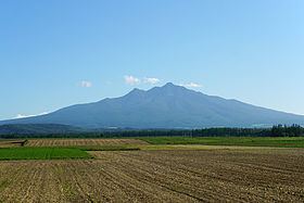
Mount Shari (斜里岳, shari-dake) is a quaternary stratovolcano and one of Japan's 100 famous mountains. Its summit is 1,547 metres (5,075 ft). The summit consists of Mount Shari, Southern Mount Shari (南斜里岳, minamishari-dake) and the western ridge. It is located on the Hokkaidō's Shiretoko Peninsula on the border of Shari and Kiyosato in Shari District, Abashiri and Shibetsu in Shibetsu District, Nemuro.
Contents
- Map of Mount Shari Shari Shari District Hokkaido Prefecture Japan
- Naming
- Geology
- Climbing routes
- References
Map of Mount Shari, Shari, Shari District, Hokkaido Prefecture, Japan
Naming
Its former name in the Ainu language was Onnenupuri. The name Shari in Ainu means marshes where reeds are growing. It is also known by the names Okhotsk Fuji (オホーツク富士, ohōtsuku fuji) or Shari Fuji (斜里富士, shari fuji).
Geology
The mountain is made mainly of andesite, dacite, and basalt.
Climbing routes
The most popular ascent route starts from the Kiyosato side. A public bus (Sharibus) runs three times a day (first at 6:30) from Shiretokoshari Station to the start of the trail.