
Elevation 1,660 m | Easiest route Scramble Last eruption 1880 | |
 | ||
Topo map Geospatial Information Authority 25000:1 羅臼25000:1 知床峠50000:1 羅臼 Similar Mount Shari, Mount Iō, Mount Meakan, Mount Rishiri, Mount Shiretoko | ||
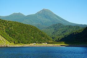
Mount Rausu (羅臼岳, Rausu-dake) is a stratovolcano on the Shiretoko Peninsula on Hokkaidō, Japan. It sits on the border between the towns of Shari and Rausu. Mount Rausu is the northeastern most Holocene volcano on Hokkaidō. It is one of the 100 famous mountains in Japan.
Contents
- Map of Mount Rausu Onnebetsumura Shari Shari District Hokkaido Prefecture 099 4100 Japan
- History
- References
Map of Mount Rausu, Onnebetsumura, Shari, Shari District, Hokkaido Prefecture 099-4100, Japan
Mount Rausu's opening festival is held annually on July 3. This day officially opens the climbing season.
In the past 2200 years it is believed that Mount Rausu erupted thrice, with a Plinian Eruption roughly 1400 years ago and a pyroclastic flow about 500 years ago.
History
References
Mount Rausu Wikipedia(Text) CC BY-SA