
Isolation 16.33 mi (26.28 km) Prominence 679 m | Elevation 3,528 m | |
 | ||
Topo map USGS 7.5' topographic mapLa Veta Pass, Colorado Similar East Spanish Peak, West Spanish Peak, Greenhorn Mountain, Mount Zwischen, Blanca Peak | ||
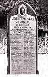
Mount Mestas is a mountain summit in the southeastern Sangre de Cristo Range of the Rocky Mountains of North America. The 11,573-foot (3,527 m) peak is located 3.2 miles (5.1 km) southeast (bearing 131°) of North La Veta Pass in Huerfano County, Colorado, United States. The mountain was known as La Veta Peak until 1949 when it was renamed in honor of PFC Felix B. Mestas, Jr. who was killed in action during the Second World War.
Contents
Map of Mt Mestas, Colorado 81055, USA
Historical namesEdit
References
Mount Mestas Wikipedia(Text) CC BY-SA