
Isolation 25.24 mi (40.62 km) Prominence 1,148 m | Elevation 3,765 m Easiest route Hiking | |
 | ||
Topo map USGS 7.5' topographic mapSan Isabel, Colorado Similar West Spanish Peak, Blanca Peak, Mount Mestas, East Spanish Peak, Hagues Peak | ||
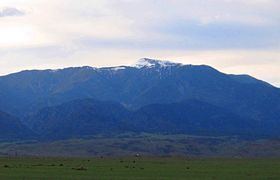
Greenhorn Mountain is the highest summit of the Wet Mountains range in the Rocky Mountains of North America. The prominent 12,352-foot (3,765 m) peak is located in the Greenhorn Mountain Wilderness of San Isabel National Forest, 5.2 miles (8.4 km) southwest by west (bearing 238°) of the Town of Rye, Colorado, United States, on the boundary between Huerfano and Pueblo counties. The summit of Greenhorn Mountain is the highest point in Pueblo County, Colorado. The peak's summit rises above timberline, which is about 11,500 feet (3,500 m) in south-central Colorado.
Contents
Map of Greenhorn Mountain, Colorado 81069, USA
GeographyEdit
The massive Greenhorn Mountain can be seen from Colorado Springs, Pueblo, Trinidad, and also from along Interstate 25 rising over 7,000 feet (2,100 m) above the great plains to the east. The mountain's habitats are protected within the secluded Greenhorn Mountain Wilderness Area, which is only accessed by a few trails and a 4-wheel drive road on its north.
Name originEdit
The name comes from the name Cuerno Verde (Green Horn) given by the colonial Spanish of the Provincias Internas to two, father and son, Jupe Comanche band mahimiana paraibo or war chiefs. The younger Cuerno Verde was known to the Comanches as "Man Who Holds Danger." On September 3, 1779 younger Cuerno Verde, his son, medicine man, four principal chiefs, and ten of his warriors, were killed near Greenhorn Mountain by the men of the expedition of Spanish troops and native American allies (Apache, Ute and Pueblo) under Juan Bautista de Anza.