
Pronunciation [kasaɡatajama] Elevation 939 m | Mountain type fault-block | |
 | ||
Similar Mount Sen, Mt Myoken, Nagusayama, Mount Seppiko, Mt Myojin | ||
At snow mt papa taka
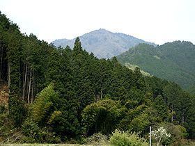
Mount Kasagata (笠形山, Kasagata-yama) is a 939.4 m (3,082 ft) mountain in the Chūgoku Mountains, located on the border of Taka and Kamikawa, Hyōgo, Japan. This mountain is one of Hyōgo 50 mountains. This mountain is an important center of Kasagatayama-Sengamine Prefectural Natural Park.
Contents
- At snow mt papa taka
- Map of Mount Kasagata Miyono Kamikawa Kanzaki District HyC58Dgo 679 2411 Japan
- Outline
- Route
- Access
- References
Map of Mount Kasagata, Miyono, Kamikawa, Kanzaki District, Hy%C5%8Dgo 679-2411, Japan
Outline
Mount Kasagata is a typical fault-block mountain in this area. The name comes from the fact that the shape of the mountain is like an umbrella ('Kasa' in Japanese)..
Route
There are three major routes to the top of this mountain. The most popular route is from Seka, Ichikawa. It takes one hour. Another route is from Mitani route and Iwazashin route start from Kadokura Bus Stop of Shinki Bus. It takes about two and half hours. The other routes are from Ōya, Taka and Miyono, Kamikawa.,