
Location Batan Island Last eruption 1454 | Mountain type Stratovolcano Elevation 1,009 m | |
 | ||
Listing Active volcano in the Philippines Similar Didicas Volcano, Babuyan Claro Volcano, Camiguin de Babuyanes, Cagua Volcano, Mount Ragang | ||
Location
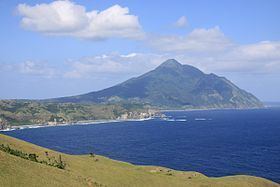
Iraya is located on Batan Island, one of the Batanes Islands, in the province of Batanes, in the Luzon Strait, north of the island of Luzon, in the Philippines.
It is the northernmost active volcano in the Philippines.
Physical features
Iraya is a heavily forested stratovolcano, with an elevation of 1,009 metres (3,310 ft) asl, and a base diameter of 5,500 metres (18,000 ft).
Adjacent volcanic edifice is Mount Matarem.
Volcanic activity
Mount Iraya last erupted in 1454, and the Philippine Institute of Volcanology and Seismology (Phivolcs) considers it as one of the active volcanoes in the Philippines.
In 1998, volcanologists recorded seismic swarms which led them to form a monitoring network on Batan Island for several months. After the swarms of tremors had diminished, the temporary stations in Barangay San Joaquin in Basco, Batanes and another near the crater, were pulled out. Seismicity or any activity relating to Iraya is still monitored by the Basco Seismological Station.
Volcanoes of the Philippines are all part of the Pacific ring of fire.