
Location Victoria, Australia Elevation 1,742 m | Prominence 594 m Parent range Great Dividing Range | |
 | ||
Similar Mount Cobbler, Mount Stirling, Mount Buggery, Mount Feathertop, Mount Bogong | ||
Mount howitt road
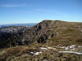
Mount Howitt is a mountain in Victoria, Australia, named for Alfred William Howitt. Located in the Wonangatta Moroka Unit of the Alpine National Park approximately 170 km north-east of Melbourne.
Contents
- Mount howitt road
- Map of Mount Howitt Howitt Plains VIC 3858 Australia
- Vegetation
- History
- Shelters and alpine huts
- In popular culture
- References
Map of Mount Howitt, Howitt Plains VIC 3858, Australia
The mountain is a popular bushwalking destination due to spectacular views and relatively easy access in summer via several popular walks including the Australian Alps Walking Track. The closest point to a road is via MacAlister Springs and the Howitt Plains, a distance of about seven kilometres. The much longer and difficult hike up the West Spur is also popular. It climbs from the Howqua River, which is generally accessed via Mount Stirling. In winter road closures restrict access to trailheads no closer than 15 km (9.3 mi) away making the area popular with remoteness-seeking back country and cross country skiers.
Vegetation
The mountain is surrounded by deep valleys, where riparian forests of Manna Gum dominate. At higher altitudes, Mountain Gum - Snow Gum forests begin to dominate and they grow on sheltered sites between 1,000 and 1,400 metres with a grassy or heathy understorey. Above this, the summit itself is above treeline
History
Aboriginal people used the King and Howqua areas as major trade routes across the Great Dividing Range, including Mount Howitt itself. They also had several quarries in the area that yielded the hard greenstone which was highly valued for tools and weapons. European settlement began in the 1840s, when grazing commenced, followed by the discovery of gold in the Howqua Valley in the 1860s.
Shelters and alpine huts
The closest shelter to Mount Howitt is the Vallejo Gantner Hut at Macalister Springs. Here there is also a reliable water source provided by a spring water pipe which flows throughout the year, even during drought. In the summer of 2013/2014 a new toilet was built at Macalister Springs with spectacular southern facing views. The toilet is a drop toilet with waste being helicoptered out when full.
In popular culture
The area around Mount Howitt is a setting for the Tomorrow series of books by John Marsden. In these books he changes the name of the nearby Cross Cut Saw to Tailor's Stitch, and the Devils Staircase to Satan's Steps.
The Man from Snowy River is one of Australia's most famous poems written by one of Australia's most famous poets, Andrew Barton (Banjo) Paterson and while the character of 'The Man' is generally believed to be based on Jack Riley from Corryong in the Upper Murray River, the film of the same name was filmed in the area around Mount Howitt. Perhaps most prominent of the locations that appears in the film is at Hells Window, on Mount Magdala, which is connected to Mount Howitt via Big Hill.