
Parent range Sierra Nevada First ascent 1864 Mountain range Sierra Nevada | Elevation 3,893 m Prominence 333 m | |
 | ||
Listing Sierra Peaks SectionWestern States Climbers Emblem peak Easiest route Cross-country hike, class 1 Similar Mount Dana, Mount Conness, Mount Lyell, Kuna Peak, North Peak | ||
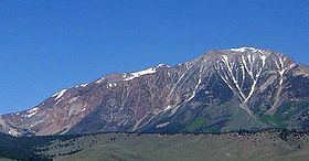
Mount Gibbs is located in the Sierra Nevada of the U.S. state of California, 2.6 miles (4 km) south of Mount Dana. The mountain was named in honor of Oliver Gibbs, a professor at Harvard University and friend of Josiah Whitney. The summit marks the boundary between Yosemite National Park and the Ansel Adams Wilderness.
Map of Mount Gibbs, California 95389, USA
The peak is accessible either from the west, starting at Tioga Pass Road, or from the east, via Bloody Canyon from the trailhead at Walker Lake. Overnight camping is not permitted on the western side of the mountain, which is part of the protected watershed of Dana Meadows and Tioga Pass. In the summer the mountain has only patchy snow, on the northern slope. The easiest ascent is via the ridge extending west from the peak; there is a steep section of loose, unstable rock, leading to the gentle ridge that forms the top of the mountain. Although the top is above the tree line, there is some sparse plant life, including wildflowers. The view of Mono Lake from the summit is partially obstructed by an outcropping to the northeast.