
Topo map NTS 83C/03 Elevation 3,747 m First ascent 1902 | Prominence 2,383 m | |
 | ||
Listing North America prominent peaks 46thCanada highest major peaks 28thCanada most prominent peaks 17thCanada most isolated peaks 36th Similar Snow Dome, North Twin Peak, Mount Andromeda, Mount Bryce, Mount Athabasca | ||
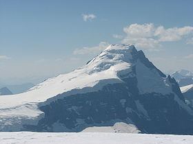
Mount Columbia is the highest point in Alberta, Canada. It is second only to Mount Robson for height and topographical prominence in the Canadian Rockies. It is located on the border between Alberta and British Columbia on the northern edge of the Columbia Icefield. Its highest point, however, lies within Jasper National Park in Alberta.
Contents
Map of Mount Columbia, Improvement District No. 12, AB, Canada
The mountain was named in 1898 by J. Norman Collie after the Columbia River. The river itself was named after the American ship Columbia Rediviva captained by Robert Gray, who first ventured over a dangerous sandbar and explored the lower reaches of the river in 1792. Mount Columbia was first ascended in 1902 by James Outram, guided by Christian Kaufmann.
Climbing routes
The normal route is on the east face, a non-technical glacier climb that is straightforward in summer, albeit with a long approach over the icefield. Other routes include the North Ridge, an excellent route with lots of variety packed into almost 2000 m of climbing. While not technically desperate, it is still not a route to be taken lightly.(Grade V, YDS 5.7, W3).