
Topo map NTS 83C/03 Elevation 3,456 m Prominence 171 m First ascender J. Norman Collie | Easiest route snow/glacier climb First ascent 1898 | |
 | ||
Mountain range Canadian Rockies, Winston Churchill Range Similar Mount Kitchener, Mount Andromeda, Mount Columbia, North Twin Peak, Mount Athabasca | ||
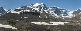
Snow Dome is a mountain located on the Continental Divide in the Columbia Icefield, where the boundary of Banff National Park and Jasper National Park meets the border of Alberta and British Columbia in Canada.
Map of Snow Dome, Columbia-Shuswap A, BC, Canada
The mountain was named in 1898 by J. Norman Collie because its snow-capped massif resembles a dome.
The mountain, reaching a height of 3,456 m (11,339 ft), is possibly a hydrological apex of North America, depending on the definition of the boundary between the Atlantic and Arctic Oceans, and of which of those hydrographic regions Hudson Bay is considered to be a part. (The other apex is Triple Divide Peak in Glacier National Park, Montana, United States.) At any rate, it is a major triple divide between three great drainage basins. Water falling on Snow Dome's summit may flow into streams that drain into the Pacific Ocean (via Bryce Creek, the Bush River and the Columbia River), the Arctic Ocean (via the Sunwapta and Athabasca Rivers), and Hudson Bay (via the North Saskatchewan River). The Dome Glacier flows to the north-east, the Stutfield Glacier to the north-west, the Columbia Glacier to the west and Athabasca Glacier flows to the east of the mountain.