
Parent peak Mt. Hakone | Elevation 1,212 m | |
 | ||
Similar Myojingatake, Myojogatake, Yaguradake, Mt Hakone, Kamiyamahakoneyama | ||
lake yamanaka mt ashigara with toy poodles
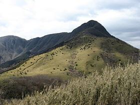
Mount Ashigara (足柄山), also known as Mount Kintoki (金時山), is the northernmost peak of the Hakone caldera, on the border of Kanagawa and Shizuoka prefectures, in the Fuji-Hakone-Izu National Park in Japan. Ashigara is not a remnant of the collapse of the old Hakone volcano itself, but rather a parasitic cone growing from its flank.
Contents
- lake yamanaka mt ashigara with toy poodles
- Map of Mount Ashigara Sengokuhara Hakone Ashigarashimo District Kanagawa Prefecture 250 0631 Japan
- Etymology
- Access
- References
Map of Mount Ashigara, Sengokuhara, Hakone, Ashigarashimo District, Kanagawa Prefecture 250-0631, Japan
Mount Ashigara is the legendary birthplace of Kintarō.
Etymology
The kanji of the mountain's name mean "leg / pattern", but the written form is ateji, meaning that the kanji were applied phonetically, and not for any symbolic representation of the mountain's characteristics or history. In old songs it is spelled out phonetically as asigari (阿之賀利) or asigara (安思我良). The name appears to be Ainu, from *áskar-i ("pure place") [aʃkaɾi], the locative form of áskan-ne ("clean, pure").
Access
Hakone side
Gotemba side
Minami Ashigara side