
Elevation 1,438 m | Last eruption June to July 2015 | |
 | ||
Similar Kamiyamahakoneyama, Mount Ashigara, Mt Ashitaka, Mount Fuji, Mount Ontake | ||
6 30 2015 hasn t erupted in 800 years mount hakone spews ash japan issues new warnings
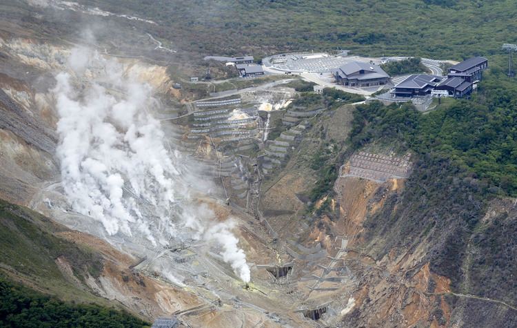
Mount Hakone (箱根山, Hakoneyama) is a complex volcano in Kanagawa Prefecture, Japan that is truncated by two overlapping calderas, the largest of which is 10 × 11 km wide. The calderas were formed as a result of two major explosive eruptions about 180,000 and 49,000–60,000 years ago. Lake Ashi lies between the southwestern caldera wall and a half dozen post-caldera lava domes that arose along a southwest–northeastern trend cutting through the center of the calderas. Dome growth occurred progressively to the south, and the largest and youngest of them, Kami-yama, forms the high point of Hakone. The calderas are breached to the east by the Haya-kawa canyon. Mount Ashigara is a parasitic cone.
Contents
- 6 30 2015 hasn t erupted in 800 years mount hakone spews ash japan issues new warnings
- Map of Mt Hakone Motohakone Hakone Ashigarashimo District Kanagawa Prefecture 250 0522 Japan
- References
Map of Mt. Hakone, Motohakone, Hakone, Ashigarashimo District, Kanagawa Prefecture 250-0522, Japan
The latest magmatic eruptive activity at Hakone occurred 2,900 years ago. It produced a pyroclastic flow and a lava dome in the explosion crater, although phreatic eruptions took place as recently as the 12–13th centuries AD.