
Topo map NTS 92/K1 Prominence 1,318 m | Elevation 2,420 m | |
 | ||
First ascent 1929 by Arthur Tinniswood Dalton and Percy Williams Easthope Similar Mount Arthur, Mount Frederick William, Middle Finger, One Eye Peak, Mount Raleigh | ||
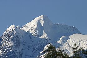
Mount alfred winter powell river b c
Mount Alfred is a mountain located at the Queen Reach arm and head of the Jervis Inlet within the Pacific Ranges of the Coast Mountains in British Columbia, Canada. The mountain is the highest in the portion of the mainland between Jervis and Toba Inlets, with its 1,318 metres (4,324 ft) prominence defined by the pass at the head of the Skwawka River, which feeds the head of Jervis Inlet. The unofficially-named Alfred Creek Falls, on Alfred Creek which drains off the mountain's glaciers southeast into the Skwawka, is one of Canada's highest waterfalls at 700 metres (2,297 ft).
Contents
- Mount alfred winter powell river b c
- Map of Mount Alfred Powell River A BC Canada
- NamingEdit
- GalleryEdit
- References
Map of Mount Alfred, Powell River A, BC, Canada
NamingEdit
The mountain was named during the 1860 survey by the HMS Plumper who charted all of the area and was named after HRH Alfred Edward “Affie” who was the third child, and second son, of Queen Victoria and Prince Albert of England, and who was Duke of Edinburgh from his birth in 1844 until his death in 1900.
The first ascent of Mount Alfred was made in 1929 by Arthur Tinniswood Dalton and Percy Williams Easthope.