
Max. length 89 km (55 mi) Province British Columbia | Max. depth 670 m (2,200 ft) | |
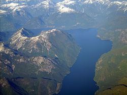 | ||
Malibu club young life club canada jervis inlet princess louisa inlet time lapes
Jervis Inlet /ˈdʒɑːrvᵻs/ is a principal inlet of the British Columbia Coast, about 95 km (59 mi) northwest of Vancouver.
Contents
- Malibu club young life club canada jervis inlet princess louisa inlet time lapes
- Map of Jervis Inlet British Columbia Canada
- Geography
- History
- Gallery
- References
Map of Jervis Inlet, British Columbia, Canada
Geography
It stretches 77 kilometres (48 mi) from its head at the mouth of the short (18 km or 11 mi) Skwakwa River to its opening into the Strait of Georgia near Texada Island. It is the deepest fjord on the British Columbia coast with a maximum depth of 732 metres (2,402 ft).
The inlet is made up of three arms or reaches:
At its uppermost stretch is Queens Reach, which takes a sharp right-angle often seen in fjord areas, to become Princess Royal Reach. Both reaches are about 20 kilometres (12 mi) in length. The flanks of the fjord and the valley of the Skwakwa River, which feeds the head of the inlet, are the site of two of Canada's highest waterfalls, James Bruce Falls (840m or 2,755 ft) and Alfred Creek Falls.
The most frequented and best known inlet in the area is Princess Louisa Inlet, with the Malibu Club and Young Life Camp at the entrance of the inlet and Princess Louisa Marine Provincial Park, including Chatterbox Falls, at its head.
At the mouth of Jervis Inlet a passenger and vehicle ferry operated by BC Ferries connects Earl's Cove (on the upper end of the Sechelt Peninsula and lower Sunshine Coast) with Saltery Bay (on the bottom end of the Malaspina Peninsula and upper Sunshine Coast).
The mouth of Sechelt Inlet connects with Jervis Inlet in the area of Earl's Cove.
Population is sparse on the shores of Jervis Inlet and there is no road access to the area. Industry includes small operations in aquaculture, commercial fishing and logging, but a substantial number of independent power projects are expected to develop in coming years.
History
The head of Jervis Inlet was once a seasonal settlement of one of the four groups that make up today's amalgamated shishalh (Sechelt) people, who called it xénichen (often anglicized as Hunaechin).
George Vancouver named the inlet after the 1791-95 expedition to search for the fabled Northwest Passage. In the Royal Navy tradition, Vancouver named this main waterway after his friend Rear Admiral Sir John Jervis (Earl of St. Vincent) for his victory over the Spanish fleet on February 14, 1797 at Cape St.Vincent in Portugal. He named St. Vincent's Bay (near the entrance of Jervis Inlet) after the location of the battle, St.Vincent Bay.
The three specific reaches of the inlet and mountains were named in the 1860 survey by the HMS Plumper, which charted the known area in honor of members of Queen Victoria's family. The waterways named during this survey mission were: Princess Louisa Inlet, Queens Reach, Princess Royal Reach, and Prince of Wales Reach. Also named were the main mountains of the area:
In the early 1900s, logging and commercial fishing developed in the Jervis Inlet area. Relatively large logging camps operated at Goliath Bay, Vancouver Bay and Hotham Sound, commercial fishing was conducted by owner-operators based in Egmont, Pender Harbour and Saltery Bay, and several fish-processing plants operated in Egmont, Pender Harbour and Saltery Bay.