
Topo map NTS 92/J4 | Elevation 1,818 m | |
 | ||
Similar Mount Arthur, Middle Finger, One Eye Peak, Mount Raleigh | ||
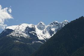
Mount Frederick William is a mountain located at the Queen Reach arm of the Jervis Inlet within the Pacific Ranges of the Coast Mountains in British Columbia Canada. The mountain was named during the 1860 survey by HMS Plumper who charted all of the area and named the mountain after the Prussian Crown Prince Frederick William, who had married Princess Victoria, the eldest child of Queen Victoria and Prince Albert.
Contents
Map of Mount Frederick William, Sunshine Coast A, BC, Canada
This mountain has been given the nickname of Frankenstein for it has the familiar profile of the famous monster's face.
GalleryEdit
References
Mount Frederick William Wikipedia(Text) CC BY-SA