
Country United States County Blackford Incorporated (town) 1870 Area 3.99 km² Zip code 47359 | State Indiana Settled 1836 Incorporated (city) 1895 Elevation 265 m Population 1,763 (2013) | |
 | ||
Weather 7°C, Wind SW at 13 km/h, 86% Humidity | ||
Montpelier /mɒntˈpiːliər/ is a city in Blackford County, Indiana, United States. This small rural community, the county's first to be platted, was established by settlers from Vermont, and is named after Vermont's capital city of Montpelier.
Contents
- Map of Montpelier IN 47359 USA
- History
- Gas Boom
- Dillinger
- Geography
- Nearby cities
- Climate
- Demographics
- 2010 census
- 2000 census
- Economy
- Culture
- Miami Indians
- Infrastructure
- Major highways
- Notable person
- References
Map of Montpelier, IN 47359, USA
Montpelier was a central participant in the Indiana Gas Boom, as natural gas was discovered near the community in 1887. More importantly, the county's first successful oil well was drilled on the south side of Montpelier in 1890. Its population quickly grew from 808 in 1890 to about 6,500 by 1896. The Gas Boom, mostly an oil boom for Montpelier, gradually ended during the first decade of the 20th century.
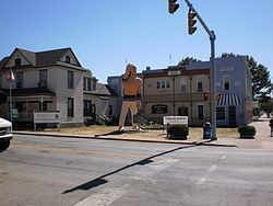
Like many boom towns, the city's population has never matched that of the boom years. The city's population was 1,805 at the 2010 census. However, the city's population stabilized many decades ago, and the community has multiple industries and an active community association. Montpelier is located near the former Godfroy Indian Reservation, and a statue of an Indian is featured prominently in the downtown district.
History
In 1836 and 1837, several groups of settlers from Vermont moved to East Central Indiana, and settled on the high ground on the south side of the Salamonie River. Abel Baldwin, a veteran of the War of 1812, was the leader of this group of Vermont natives. They named their community Montpelier, after the capital of their original home state. Baldwin and his son-in-law, civil engineer John Cook, surveyed the area in 1836, and it was platted on September 5, 1837. The original plat had 16 blocks with a total of 154 lots.
At the time Montpelier was settled, it was part of Jay County. The western portion of Jay County was split away in 1838 to form Blackford County. Montpelier was not the first community in what would become Blackford County – a village named Matamoras existed earlier. However, Montpelier was platted first, and Matamoras was essentially a ghost town after the 1880s.
Beginning in September 1870, the Fort Wayne, Cincinnati & Louisville Railroad connected Fort Wayne with Muncie, Indiana, and Montpelier was (and still is) on this line. With dramatically improved transportation for the community, Montpelier became incorporated as a town at the end of 1870. By that time, the town had grown to a population of 231.
Gas Boom
In 1887, natural gas was discovered in Blackford County, and the area began its participation in the Indiana Gas Boom. While natural gas was found throughout Blackford County, crude oil was found mostly in the county's Harrison Township, which includes Montpelier. Blackford County's first successful oil well, located just south of Montpelier, began producing during 1890. Montpelier was thought to be "the very heart of the greatest natural gas and oil field in the world". By the mid-1890s, about two-thirds of Harrison Township (25 square miles) was considered part of an oil-producing region. Montpelier became a city where “money and whiskey flowed frequently”, and numerous other “recreational activities” were available. Oil production from the Trenton Gas and Oil Field surrounding Montpelier began decreasing during the first decade of the 20th century, and the Gas Boom (or Montpelier's oil boom) gradually came to an end. Montpelier began a return to normalcy and its population (like many boom towns) has never exceeded its Gas Boom peak.
Dillinger
The Montpelier National Bank was robbed by three men on the afternoon of August 4, 1933. The robbery lasted about ten minutes, and no shooting was involved. The robbers quietly left town, driving east on Indiana State Road 18, without being followed. It was later determined, by the Federal Bureau of Investigation, that the robbers were John Dillinger and the Dillinger Gang.
Geography
Montpelier is part of East Central Indiana and Northern Indiana. Future Northern Indiana, including what became Harrison Township and Montpelier, was flattened by two glaciers millions of years ago. These glaciers are also responsible for the rich Blackford County farmland, which includes the land surrounding Montpelier.
Located in the Harrison Township portion of Blackford County, Indiana, Montpelier is adjacent to the Salamonie River. It is located 40 miles (64 km) south of Fort Wayne, Indiana, and 75 miles (121 km) northeast of Indianapolis.
According to the 2010 census, Montpelier has a total area of 1.54 square miles (3.99 km2), all land.
Nearby cities
Climate
Montpelier has a typical Midwestern humid continental seasonal climate. There are four distinct seasons, with winters being cold with moderate snowfall, while summers can be warm and humid. The highest average temperature is in July at 84 °F (29 °C), while the lowest average temperature is in January at 18 °F (−8 °C). However, summer temperatures can top 90 °F (32 °C), and winter temperatures can drop below 0 °F (−17 °C). Average monthly precipitation ranges from about 2 to 4 inches (5 to 10 cm), with the heaviest occurring during June, July, and August. The highest recorded temperature was 103.0 °F (39.0 °C) on June 26, 1988, and the lowest recorded temperature was −26.0 °F (−32.0 °C) on January 19, 1994.
Demographics
Although Montpelier's peak population shown in the adjacent table (source: U.S. Census) is shown as 3,405, the city is thought to have had over 6,500 residents around 1896 during the Indiana Gas Boom.
2010 census
As of the census of 2010, there were 1,805 people, 708 households, and 470 families residing in the city. The population density was 1,172.1 inhabitants per square mile (452.6/km2). There were 823 housing units at an average density of 534.4 per square mile (206.3/km2). The racial makeup of the city was 97.9% White, 0.3% African American, 0.3% Native American, 0.1% Asian, 0.2% from other races, and 1.2% from two or more races. Hispanic or Latino of any race were 0.9% of the population.
There were 708 households of which 36.7% had children under the age of 18 living with them, 45.3% were married couples living together, 13.0% had a female householder with no husband present, 8.1% had a male householder with no wife present, and 33.6% were non-families. 29.4% of all households were made up of individuals and 11.3% had someone living alone who was 65 years of age or older. The average household size was 2.55 and the average family size was 3.10.
The median age in the city was 36.3 years. 28.1% of residents were under the age of 18; 8% were between the ages of 18 and 24; 25.2% were from 25 to 44; 25.3% were from 45 to 64; and 13.1% were 65 years of age or older. The gender makeup of the city was 50.1% male and 49.9% female.
2000 census
As of the census of 2000, there were 1,929 people, 802 households, and 539 families residing in the city. The population density was 1,757.9 people per square mile (677.1/km²). There were 897 housing units at an average density of 817.4 per square mile (314.8/km²). The racial makeup of the city was 97.46% White, 0.10% African American, 0.31% Native American, 0.16% from other races, and 1.97% from two or more races. Hispanic or Latino of any race were 1.04% of the population.
There were 802 households out of which 32.3% had children under the age of 18 living with them, 50.9% were married couples living together, 11.2% had a female householder with no husband present, and 32.7% were non-families. 29.3% of all households were made up of individuals and 12.7% had someone living alone who was 65 years of age or older. The average household size was 2.41 and the average family size was 2.95.
In the city, the population was spread out with 27.3% under the age of 18, 8.7% from 18 to 24, 28.6% from 25 to 44, 21.7% from 45 to 64, and 13.7% who were 65 years of age or older. The median age was 35 years. For every 100 females there were 95.0 males. For every 100 females age 18 and over, there were 93.8 males.
The median income for a household in the city was $30,175, and the median income for a family was $38,804. Males had a median income of $29,152 versus $21,402 for females. The per capita income for the city was $15,076. About 6.6% of families and 9.5% of the population were below the poverty line, including 9.0% of those under age 18 and 9.0% of those age 65 or over.
Economy
Montpelier is located in a rural agricultural area, and has its own grain elevator. The city also has some manufacturing establishments, and its major businesses provide employment for over 400 people. These businesses include Emhart-Gripco, Smith Consulting, Indiana Veneer, BRC Rubber & Plastics, Indiana Box, and others. Montpelier also has a 50-acre industrial park.
Culture
Montpelier has a long history of racing. During the 19th Century, there were at least two race tracks for horses near Montpelier. Montpelier's own horse track was established in 1903. This track was very popular and drew crowds of 3,000. During the 1920s, a rebuilt track became known as the fastest half mile in Indiana. During the 1950s, the track became a stock car racing track, but reverted to horses in the 1960s. The track closed in 1973, but reopened in 1985 for stock car races and horse racing. Today, Montpelier Raceway features sanctioned stock car racing.
The Public Library of Montpelier and Harrison Township was built in 1907 and 1908. The building was made possible by a donation of $10,000 from philanthropist (and former business magnate) Andrew Carnegie. Built in the Classical Revival style of architecture, this building (under the historical name of Montpelier Carnegie Library) was added to the National Register of Historic Places in 2007. It is one of only three individual buildings in Blackford County listed in the National Register. (The county also has a Historic District.)
Montpelier's First Baptist Church was founded by Franklin Baldwin, brother of the leader of Montpelier's first settlers, Abel Baldwin. The congregation was organized in 1838. The present church building, located in downtown Montpelier, was constructed in 1907 and 1908. The building has been remodeled since that time.
High school basketball is very popular in Indiana, and Montpelier has been a strong participant. Despite its smaller size, Montpelier High School won five sectional basketball tournament championships. After a high school consolidation, Montpelier students began attending Blackford High School – and Blackford has won ten sectional championships. Additional sporting activities in Montpelier include Little League baseball, Tee Ball, and softball. Golfing, camping, and fishing are also available nearby.
The Montpelier Jamboree is an annual celebration that was first held in 1945. This Labor Day weekend celebration features musical acts, a Jamboree Queen contest, and other activities.
Miami Indians
The former Godfroy Reservation, an Indian reservation for Chief Francis Godfroy and Miami Indians from 1827 until 1836, is located on the Salamonie River near Montpelier. (Francis is the English pronunciation of Godfroy's real name Francois. The Indian pronunciation of Francois was Palonzwa.) Godfroy's father was French, and his mother was from the Miami tribe. A big man at six feet tall and 300 pounds, Godfroy was the last war chief of the Miami Nation. A sculpture of an Plains Indian stands in downtown Montpelier, donated by Chief Larry Godfroy. The sculpture is best known as being seen in the introductory montage on the television program Parks and Recreation.
Infrastructure
Montpelier has its own elementary school, and high school students attend the county's Blackford High School. Five universities, including Ball State University and Taylor University, are located not more than 30 miles (48 km) from Montpelier.
The Norfolk Southern Railway provides freight railroad service connecting Montpelier to Fort Wayne and Indianapolis. This railroad, known as the Lake Erie and Western Railroad in the 1890s during the Gas Boom, was very important for the growth of Montpelier. Indiana Highway 18 runs through Montpelier, and Interstate 69 is 14 miles (23 km) west. The nearest airport with commercial flights is located 40 miles (64 km) north in Fort Wayne.