
Elevation 3,045 m First ascender Victor de Cessole | Province Province of Cuneo | |
 | ||
Similar Cime de la Malédie, Cime du Gélas, Grand Capelet, Monte Argentera, Mont Bégo | ||
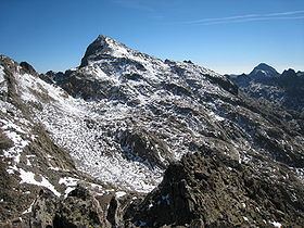
Monte Clapier (French: Mont Clapier) is a mountain in the Maritime Alps, on the boundary between the province of Cuneo (Piedmont, northern Italy) and the French region of Provence-Alpes-Côte-d'Azur.
Contents
- Map of Monte Clapier 12010 Entracque Province of Cuneo Italy
- Geography
- Geology
- Climbing
- View
- Maps
- References
Map of Monte Clapier, 12010 Entracque, Province of Cuneo, Italy
Geography
It is part of the Mercantour massif.
Monte Clapier is home to the southernmost glacier in the Alps, located on the Italian side at some 40 km from the sea. Furthermore, it is the southernmost mountain in the Alps exceeding 3000 meters in height.
Geology
Geologically, the mountain is formed by granitoid gneiss, with outcrops of amphibolic agmatites (granitoid migmatites).
Climbing
It may be climbed from the Refuge Nice in around two-and-a-half to three hours, initially northward along a narrow path towards the Lacs de Mont Clapier, then eastward along a cairned route (no path visible) across rough, bouldered ground.
View
The view is extensive stretching from the Mediterranean to the south to the high Alps to the northeast. Monte Viso is prominent to the north and 4000m peaks like the Matterhorn, Monte Rosa and the Weissmies, and even Corsica, are visible on clear days.