
Elevation 3,143 m First ascent 1864 | Prominence 669 m First ascender Paolo di Saint-Robert | |
 | ||
Listing Alpine mountains above 3000 m Similar Cime de la Malédie, Monte Clapier, Monte Argentera, Caïres de Cougourde, Grand Capelet | ||
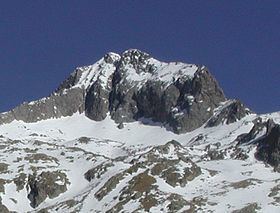
Cime du Gélas (Italian: Monte Gelàs) is a 3,143 m high mountain on the boundary between France (Provence-Alpes-Côte d'Azur region) and Italy (province of Cuneo). It is part of the Maritime Alps.
Contents
Map of Cime du G%C3%A9las, Saint-Martin-V%C3%A9subie, France
It is the highest peak of the Mercantour National Park, while on the Italian side it is included in the Maritime Alps Natural Park. Geologically, it is part of the Mercantour-Argentera massif, and is mostly formed by granitoid gneiss. The peak is composed of two smaller ones, divided by a gorge; the highest peak is the northern one, which is topped by a cross built here by priests from Cuneo.
The mountain's name derives from the glaciers which occupy its northern slopes, which have however reduced substantially during the late 20th century.
MapsEdit
References
Cime du Gélas Wikipedia(Text) CC BY-SA