
Elevation 4,304 m First ascent 14 July 1775 | Prominence 58 m Mountain range Graian Alps | |
 | ||
Easiest route From Refuge du Goûter, 3,817 m, (F) Similar Aiguille de Bionnassay, Aiguille du Goûter, Mont Maudit, Mont Blanc du Tacul, Dôme de Rochefort | ||
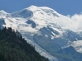
The Dôme du Goûter (4,304 m) is a mountain in the Mont Blanc massif. It is a shoulder of Mont Blanc, whose summit lies two kilometres to the south-east. The Dôme is traversed on ascents of Mont Blanc via the Bosses route.
Map of D%C3%B4me du Go%C3%BBter
The summit of the Dôme is marked as lying entirely within France on the French Institut Géographique National (IGN) map [1], although on Italian Istituto Geografico Militare (IGM) map [2] the summit appears to lie on the frontier between France and Italy.
References
Dôme du Goûter Wikipedia(Text) CC BY-SA