
- Tree Shiogama Sakura Phone number 022-364-1111 Population 54,621 (Aug 2014) | Area 17.86 km² Local time Sunday 2:45 AM | |
 | ||
Weather 3°C, Wind NW at 11 km/h, 95% Humidity Points of interest Shiogama Jinja, Shiogama Shrine Museum, Shiogama Sugimura Jun Muse, Iboishi Park, Kanno Museum | ||
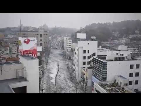
Tsunami in shiogama city japan 2011 march
Shiogama (塩竈市 and 塩釜市, Shiogama-shi) is a city located in Miyagi Prefecture, Japan. As of August 2014, the city had an estimated population of 54,621 and a population density of 3060 persons per km². The total area was 17.86 km².
Contents
- Tsunami in shiogama city japan 2011 march
- Map of Shiogama Miyagi Prefecture Japan
- Tsunami in shiogama miyagi prefecture japan
- Geography
- Neighboring municipalities
- Etymology
- History
- Economy
- Railway
- National highways
- Miyagi Prefectural Highways
- Festivals
- Notable people from Shiogama
- References
Map of Shiogama, Miyagi Prefecture, Japan
Tsunami in shiogama miyagi prefecture japan
Geography
Shiogama is in north-central Miyagi Prefecture, bordered by the Pacific Ocean to the east.
Neighboring municipalities
Etymology
"Shiogama" means "salt furnace" and refers to a local Shinto ritual involving the making of salt from sea water, still performed every July. The name is sometimes written using the kanji 塩釜 rather than 塩竈 and both spellings are officially permitted. Both 釜 and 竈 are pronounced gama in compounds, but as lone words they are pronounced kama and kamado, respectively. A kamado (竈, "furnace") is a what a kama (釜, "kettle") is placed upon, and so the two are not completely interchangeable. 塩竈 is the form officially used by the city, but for ease of writing, the 10-stroke 釜 is often used in place of the 21-stroke 竈, such as in Shiogama Station.
Shiogama Jinja uses the rendering 鹽竈, with an archaic character for salt. This third form is rarely seen outside of this context.
History
The area of present-day Shiogama was part of ancient Mutsu Province, and has been settled since at least the Jomon period by the Emishi people. During the Nara period, the area came under the control of colonists from the Yamato dynasty based at nearby Tagajō and was the most important seaport in Mutsu. The ruins of the provincial capital of Mutsu Province have been found within the city borders. During later portion of the Heian period, the area was ruled by the Northern Fujiwara. During the Sengoku period, the area was contested by various samurai clans before the area came under the control of the Date clan of Sendai Domain during the Edo period, under the Tokugawa shogunate. The town of Shiogama was established with the creation of the municipalities system on April 1, 1889. Parts of Tagajō and Shichigahama were incorporated into Shiogama of September 1, 1938. Shiogama was raised to city status on November 23, 1941 (187th, nationally; 3rd in Miyagi). The city annexed the Gyūchi area of neighboring Tagajō on December 1, 1949 and the village of Urato on April 1, 1950.
The city was affected by the tsunami caused by the 2011 Tōhoku earthquake, although damage to its fishing industry turned out to be light.
Economy
The economy of Shiogama is largely based on commercial fishing, especially of tuna, and fish processing. The city also boasts of the highest density of sushi restaurants in Japan.