
Highest elevation 445 m (1,460 ft) Population 6 (2004) Elevation 445 m | Coastline 25 km (15.5 mi) Highest point Kinkasan Area 10.28 km² | |
 | ||
Similar Kinkasankoganeyama Shrine, Oshika Peninsula, Kinkasan Lighthouse, Tashirojima, Gobansho Park | ||
Kinkasan island full trek
Kinkasan (金華山, Kinkasan, or Kinkazan), is a small island in Miyagi Prefecture in north-eastern Japan. It lies in the Pacific Ocean approximately one kilometer off the Oshika Peninsula.
Contents
- Kinkasan island full trek
- Map of Kinkasan Ayukawahama Ishinomaki Miyagi Prefecture 986 2523 Japan
- The highest point on kinkasan
- Geography
- History
- References
Map of Kinkasan, Ayukawahama, Ishinomaki, Miyagi Prefecture 986-2523, Japan
The highest point on kinkasan
Geography
Kinkasan is 9.5 km2 (3.7 sq mi) in area, and its highest point is the pyramid-shaped Mount Kinka, which stands at 445 m (1,460 ft).
It can be reached by ferry from Ishinomaki.
History
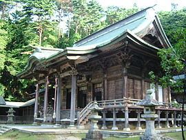
There is a shrine on the island, called Koganeyama-jinja, which dates from the 8th century.
References
Kinkasan Wikipedia(Text) CC BY-SA