
Tehsils 4 Area 4,521 km² Local time Tuesday 8:56 AM | Website Official website Tehsil 4 Average annual precipitation 1,043 | |
 | ||
Weather 21°C, Wind SW at 2 km/h, 40% Humidity | ||
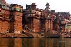
Mirzapur district is one of the 75 districts of Uttar Pradesh state in northern India. The district is bounded on the north by Sant Ravidas Nagar and Varanasi districts, on the east by Chandauli district, on the south by Sonbhadra district and on the northwest by Allahabad district. The district occupies an area of 4521 km2. Mirzapur town is the district headquarters. Mirzapur district is a part of Mirzapur division. This district is known for the Vindhyavasini temple in Vindhyachal. It consist of several Ghats where historical sculptures are still present. During the Ganges festival these Ghats are decorated with lights and diyas. It is currently a part of the Red Corridor.
Contents
Map of Mirzapur, Uttar Pradesh
As per government data the district code of Mirzapur is 199.
Divisions
The district consists four Tehsils. These are Mirzapur (sadar), Lalganj, Marihan and Chunar. These four tehsils are further divided into twelve blocks.
Economy
In 2006 the Ministry of Panchayati Raj named Mirzapur one of the country's 250 most backward districts (out of a total of 640). It is one of the 34 districts in Uttar Pradesh currently receiving funds from the Backward Regions Grant Fund Programme (BRGF).
Demographics
According to the 2011 census Mirzapur district has a population of 2,494,533, roughly equal to the nation of Kuwait or the US state of Nevada. This gives it a ranking of 174th in India (out of a total of 640). The district has a population density of 561 inhabitants per square kilometre (1,450/sq mi) . Its population growth rate over the decade 2001-2011 was 17.89%. Mirzapur has a sex ratio of 900 females for every 1000 males, and a literacy rate of 70.38%. Female Literacy rate here is 54%.
Languages
Languages spoken include Agariya, an Austroasiatic tongue with approximately 72 000 speakers; Awadhi, which has a lexical similarity of 72-91% with Hindi (compared to 60% for German and English) and is spoken by about 7 800 000 in Bagelkhand; and Bagheli, a tongue in the Bagheli language group with almost 40 000 000 speakers, written in both the Devanagari and Kaithi scripts.Bhojpuri is also widely spoken in this part of the state.