
Basin countries United States Max. depth 42 ft (13 m) Surface elevation 381 m Islands Malone Island | Surface area 207 sq mi (536 km) Area 536.1 km² | |
 | ||
Primary inflows | ||
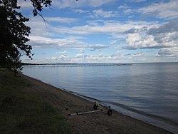
Glaciers visit izatys resort mille lacs lake mn
Mille Lacs Lake (also called Lake Mille Lacs or Mille Lacs) is a large but shallow lake in the U.S. state of Minnesota. It is located in the counties of Mille Lacs, Aitkin, and Crow Wing, roughly 100 miles north of the Minneapolis-St. Paul metropolitan area.
Contents
- Glaciers visit izatys resort mille lacs lake mn
- Map of Mille Lacs Lake Minnesota USA
- Hot walleye bite on mille lacs lake mn in depth outdoors tv season 9 episode 5
- Physical features
- Fishing
- History
- Towns on Mille Lacs Lake
- References
Map of Mille Lacs Lake, Minnesota, USA
Mille Lacs means "thousand lakes" in French. In the Ojibwe language, the lake is called Misi-zaaga'igan ("grand lake").
Hot walleye bite on mille lacs lake mn in depth outdoors tv season 9 episode 5
Physical features
Mille Lacs is Minnesota's second-largest inland lake at 132,516 acres (536 km2), after Red Lake. The maximum depth is 42 feet. 20- to 38-foot depth ranges cover much of the main lake. Gravel and rock bars cover the southern half of the lake. Two islands in the center make up Mille Lacs National Wildlife Refuge, the smallest in the United States.
Fishing
Shallow reef-top fishing exists on all sides of the lake. Deep-water angling takes place on the southern deep gravel and rocks as well as on dozens of mud flats in the north half of the lake. Shoreline break fishing on varied bottom types occurs all around the lake. The weed line is at nine to twelve feet. There are many local fisherman's names for some features of the lake. Spirit Island, the small rock-made island in the south west region of the lake, is often referred to as Bird Crap Island or Stinky Stony Island.
The lake has many species of fish including walleye, northern pike, muskie, jumbo perch, smallmouth bass, largemouth bass, black crappie, burbot, and tullibee. It is one of Minnesota's most popular fishing lakes. Ice fishing houses number in the thousands during the winter. It is a prime spawning grounds for walleye. Billions of walleye eggs and fry are produced there every year. In the absence of a thermocline, fish can travel the whole area of the lake.
History
Archaeologists indicate that it is one of the earliest known sites of human settlement in the state of Minnesota. The Rum River drains from Lake Mille Lacs into the Mississippi River to the south in Anoka. Father Hennepin State Park, Mille Lacs Kathio State Park, and portions of the Mille Lacs Indian Reservation lie along the lake. On early French maps, the lake was also known as Lac Buade or Minsisaugaigun. On a 1733 Henry Popple map, for example, Mille Lacs Lake is shown as "Lake Miſsiſsucaigan or Baude"; as late as 1843 it was referred to as "Mini Sagaigonin or Mille Lacs" on government maps.
In the Dakota language, the lake is known as mde waḳaŋ (Spiritual/Mystic Lake), which was the basis for the name of the Mdewakanton division of the Santee Sioux. In Ojibwe, the lake is known as Misi-zaaga'igan megwe Midaaswaakogamaakaan (Grand/Great/Big Lake in the Region of a Thousand Lakes), or simply as Misi-zaaga'igan, as it is the largest lake in the Brainerd Lakes Area. The lake was thus named "Mille Lacs Lake" as the Brainerd Lakes Area was called "Region of Thousand Lakes" (pays des mille lacs) in French.
In 2013, a windblown wall of ice called an ice shove damaged houses on the lake shore.