
Opened September 2003 Bridge type Cantilever bridge | Clearance below 35 m Total length 998 m | |
 | ||
Carries Original:4 lanes of M2 plus hard shoulder & BridlewayNew: 4 lanes of M2 plus hard shoulderRail: 2 tracks of High Speed 1 Width Original: 34.44 metres (113 ft)New:Rail: Longest span Original: 152.4 metres (500 ft)New:Rail:152.4 metres (500 ft) Similar Rochester Bridge, Rainham (Kent) railway st, East Farleigh Bridge, Teston Bridge, Cuxton railway station | ||
The Medway Viaducts are three bridges or viaducts that cross the River Medway near Rochester in north Kent, England. The two road bridges carry the M2 motorway carriageways. The other viaduct carries the High Speed 1 railway line.
Contents
- Map of Medway Viaduct Rochester ME2 1LE UK
- Original motorway viaduct
- Second motorway viaduct
- Railway viaduct
- References
Map of Medway Viaduct, Rochester ME2 1LE, UK
Original motorway viaduct
Opened on 29 May 1963, by Ernest Marples, Minister of Transport, the Medway bridge formed a key piece of the M2 motorway. It originally had a six-lane (two London-bound, two coast-bound, two hard shoulder) formation. In addition, a footpath either side that doubled as a small service road for maintenance and pedestrians. These footpaths were part of the North Downs Way, offering panoramic views of the Medway Valley and beyond. During the M2 widening, the original bridge was refurbished and strengthened. The central span, which was made from concrete beams, was replaced with steel girders. The concrete beams were lowered down on to a river barge underneath. As part of the M2 widening, the original bridge had street lighting fitted to it for the first time.
Second motorway viaduct
Completed in 2003, as part of the M2 widening project, the second motorway bridge is the newest of the three that cross the River Medway at this point. The bridge was built south of the original bridge. The formation of the M2 motorway crossing was changed. The original bridge would be changed to three coast-bound lanes, a hard-shoulder and both footpaths were reduced in size. The south facing footpath was closed, leaving only one path for pedestrians. The newer of the two bridges had the same formation, but changed to London-bound lanes.
In 2003, the bridge won the Concrete Society’s Civil Engineering Category award for, "outstanding merit in the use of concrete". It was presented to Doka UK Formwork Technologies. A plaque can be seen on one of the upright support legs, on the Strood side.
Railway viaduct
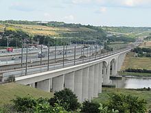
The western bridge carries High Speed 1 (HS1), the high-speed rail link that connects London with the Channel Tunnel.
The rail viaduct is 1.3 kilometres long. The viaduct is a multi-span structure, with typical approach spans of 40.5 m, spanning the River Medway, Wouldham Road and Burham Roads in Borstal. with a central navigation span of 152 m. The viaduct substructure is of reinforced concrete pier columns supported on bored piles. A feature of the columns is that they are in a "V" shape to provide greater lateral support and stability in the event of two high-speed trains using their emergency brakes.
The bridge deck was pushed out from the abutments on the east and west banks of the river during construction using hydraulic ram pistons.
On 30 July 2003, a specially formed Eurostar train crossed the viaduct and in to the Nashenden Valley at 208 m.p.h. (334.7 km/h) which was a new UK rail speed record.To celebrate the tenth anniversary of the UK rail speed record, a plaque was placed overlooking the railway viaduct.
On 29 May 2013 the M2 celebrated its 50th anniversary.
All three bridges pass over the Medway Valley Line (to Paddock Wood) and the Chatham Main Line (to Victoria) railway lines.