
Postal code G Area 35,865 km² Province Québec | Time zone EST (UTC-5) Area code 819, 873 Population 263,603 (2011) | |
 | ||
Regional County Municipalities (RCM) and Equivalent Territories (ET) 3 RCM, 3 ETLes ChenauxMaskinongéMékinac Regional County MunicipalityLa Tuque (ET)Shawinigan (ET)Trois-Rivières (ET) Website www.mauricie.gouv.qc.ca Points of interest Mokotakan, Vallée Du Parc, Centre des arts, Wapizagonke Lake, Église Notre‑Dame‑de‑la‑Présentation de Shawi | ||
G te le temps des villages shawinigan mauricie qc
Mauricie ([mɔʁisi]) is a traditional and current administrative region of Quebec. La Mauricie National Park is contained within the region, making it a prime tourist location. The region has a land area of 35,855.22 km² (13,843.78 sq mi) and a 2006 census population of 258,928 residents. Its largest cities are Trois-Rivières and Shawinigan.
Contents
- G te le temps des villages shawinigan mauricie qc
- Map of Le Centre de la Mauricie QC Canada
- Ville de shawinigan laur at r gional 2015 mauricie et centre du qu bec
- Subdivisions
- School Boards
- References
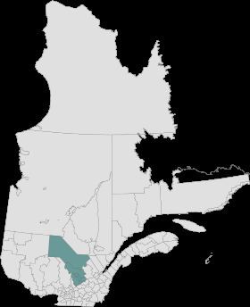
Map of Le Centre-de-la-Mauricie, QC, Canada
The word Mauricie was coined by local priest and historian Albert Tessier and is based on the Saint-Maurice river which runs through the region on a North-South axis.
Mauricie administrative region was created on August 20, 1997 from the split of Mauricie–Bois-Francs administrative region into Mauricie and Centre-du-Québec. However, the concept of Mauricie as a traditional region long predates this.
Ville de shawinigan laur at r gional 2015 mauricie et centre du qu bec
Subdivisions
Regional County Municipalities
Equivalent Territories
Independent Municipalities
Aboriginal Reserves
School Boards
Francophone:
Anglophone: