
Existed: 1933 – present Constructed 1933 | Length 33.75 km | |
 | ||
Counties | ||
Route 109 is a state highway in eastern Massachusetts. It runs from Route 16 in Milford east to the VFW Parkway in Boston. Most of Route 109 runs along a portion of the Hartford and Dedham Turnpike.
Contents
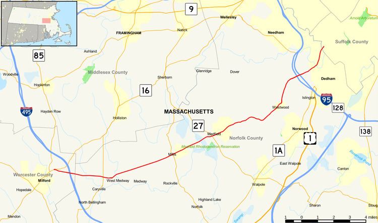
Map of MA-109, Massachusetts, USA
Route description
Route 109 begins at Route 16 in Milford, just east of Route 85's southern terminus. The route proceeds to the east, meeting Interstate 495 at Exit 19 before crossing into Norfolk County and the town of Medway. Route 109 passes through northern Medway, crossing Route 126 along the way before turning onto Main Street. The highway crosses the Charles River and continues into Millis, where it crosses Route 115 in the center of town. The road then enters Medfield, passing through the center of town where it intersects Route 27.
East of Medfield, Route 109 travels along the Dover - Walpole town line before entering Westwood. The highway passes through the town, easing towards the urban landscape of metro Boston. North of the center of town, Route 109 interchanges with Interstate 95 (Route 128) at Exit 16 as it enters Dedham. Route 109 passes through northwest Dedham, crossing the Charles twice more before crossing into the Boston neighborhood of West Roxbury, where it immediately meets the VFW Parkway and ends.
The VFW Parkway, which has its southern terminus at the intersection with Route 109, formerly carried U.S. Route 1 into the city, before US-1 was rerouted along I-95 and I-93 through Braintree and downtown Boston, due to the cancellation of I-95 in Boston during the 1970s. As such, Route 109 no longer ends at a numbered highway, although the Boston-Providence Turnpike runs south from this intersection to join the current US-1 at its interchange with I-95/Route 128. South of the interchange, US-1 runs along the Turnpike.
History
The Hartford and Dedham Turnpike was chartered on March 9, 1804 to close a gap in the turnpikes that were being built to replace the Middle Post Road between Dedham and Hartford. It ran from Dedham southwest to West Medway, where it continued as the earlier Ninth Massachusetts Turnpike and Boston Turnpike to Hartford, Connecticut. North of Dedham, the Norfolk and Bristol Turnpike continued to Boston. The turnpike, built in 1807, was never a success. In 1821 it was closed to all but local travel due to its condition; it became a free road in 1830, with the rest of the route to Hartford becoming free in 1838.
The path of the road is now mostly covered by Route 109. The turnpike entered Dedham center using High Street, and in Westwood, Dover and Medfield the old turnpike exists as Hartford Street, while Route 109 uses the older alignment with better grades. Near the west end, Route 109 turns west towards Milford, and the turnpike continues southwest on Main Street to end at its merge with Route 126 and the Middle Post Road.
The original Route 109 went from Pittsfield to West Brookfield along what is now Route 9. This number was removed by 1933. The modern 109 was posted by 1933, presumably when the old one was taken down.