
Country United States Incorporated 1780 Elevation 94 m Population 27,999 (2010) | State Massachusetts Settled 1662 Demonym(s) Milfordian Zip code 01757 Local time Wednesday 8:06 AM | |
 | ||
Weather 2°C, Wind W at 23 km/h, 49% Humidity | ||
Video of 45 camp street milford massachusetts real estate homes
Milford is a town in Worcester County, Massachusetts, United States. The population was 27,999 according to the 2010 census. First settled in 1662 and incorporated in 1780, Milford became a booming industrial and mining community in the 19th century due to its unique location which includes the nearby source of the Charles River, the Mill River, the Blackstone River watershed, and large quantities of Milford pink granite.
Contents
- Video of 45 camp street milford massachusetts real estate homes
- Map of Milford MA USA
- History
- Geography
- Adjacent towns
- Demographics
- Economy
- Government
- Library
- Education
- Annual events
- Sites of interest
- Media
- Notable people
- References
Map of Milford, MA, USA
History
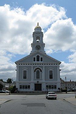
Milford was first settled in 1662 as a part Mendon. The King Philip's War destroyed the town in 1676, but settlers returned in 1680. The Mill River flows through Milford and had several conspicuous fords that were familiar to the Native Americans, and used by the early white settlers. These "Mill (river) fords" gave Milford its name. Milford was incorporated April 11th, 1780 and the first Town Hall built in 1819; a brick structure later named the Town House School. The Milford Town Hall was built in 1854 by architect Thomas Silloway.
Milford is renowned for its pink Milford granite, discovered in 1870. Milford quarries fueled the local economy until about 1940. The granite has been used for local buildings such as Memorial Hall, the Bancroft Memorial Library in Hopedale, Worcester City Hall, and the Boston Public Library. Other notable buildings include the original Pennsylvania Station in New York City, the main post office in New York City, and most recently the Singapore Changi Airport in 2002. The Battle Monument at West Point is also made of Milford granite, and is reputed to be the largest column of polished granite in the Western Hemisphere.
The Milford Hospital was donated in 1903 by Governor Eben Sumner Draper. Today, the health care facility exists as the Milford Regional Medical Center. In January 2008, the Center opened a cancer treatment facility with the Dana–Farber Cancer Institute. The Center is affiliated with UMass Medical Center as a teaching hospital. In 2015 the hospital completed a $54 million expansion project that created a new emergency department and updated the intensive care unit, as well as patient rooms.
Geography
According to the United States Census Bureau, the town has a total area of 14.9 square miles (39 km2), of which 14.6 square miles (38 km2) is land and 0.3 square miles (0.78 km2), or 1.82%, is water. Milford is drained by the Charles River.
The town is crossed by Interstate 495, as well as state routes 16, 85, 109, and 140.
Adjacent towns
Milford is located in Eastern Massachusetts, bordered by:
Demographics
As of the census of 2000, there were 26,799 people, 10,420 households, and 7,200 families residing in the town. The population density was 1,835.6 people per square mile (708.7/km²). There were 10,713 housing units at an average density of 733.8 per square mile (283.3/km²). The racial makeup of the town was 92.95% White, 1.35% Black or African American, 0.11% Native American, 1.76% Asian, 0.06% Pacific Islander, 1.99% from other races, and 1.77% from two or more races. Hispanic or Latino of any race were 4.36% of the population.
There were 10,420 households out of which 33.4% had children under the age of 18 living with them, 54.0% were married couples living together, 11.2% had a female householder with no husband present, and 30.9% were non-families. 25.6% of all households were made up of individuals and 9.5% had someone living alone who was 65 years of age or older. The average household size was 2.54 and the average family size was 3.08.
In the town, the population was spread out with 24.8% under the age of 18, 6.5% from 18 to 24, 33.2% from 25 to 44, 22.6% from 45 to 64, and 12.9% who were 65 years of age or older. The median age was 37 years. For every 100 females there were 94.3 males. For every 100 females age 18 and over, there were 90.6 males.
The median income for a household in the town was $50,856, and the median income for a family was $61,029. Males had a median income of $42,173 versus $30,989 for females. The per capita income for the town was $23,742. About 5.8% of families and 7.2% of the population were below the poverty line, including 8.9% of those under age 18 and 10.4% of those age 65 or over.
Economy
Milford has been growing at a fast rate since the introduction of Interstate 495, which opened in the area with dual exits at Route 85 and Route 109 in 1969. Since then many major retailers have opened in town. Milford was fictitiously featured in a 2008 episode of the Fox television series Fringe.
Government
The core of Milford's governing system is the representative town meeting, where elected citizens can voice their opinions, but more importantly, directly effect changes in the community. Along with a Board of Selectmen, Town Administrator, Planning Board, Finance Committee, etc., the citizens of Milford have input into how the town is run.
The Massachusetts Department of Correction is headquartered in Milford.
Library
The Milford Public Library was established in 1858. In fiscal year 2008, the town of Milford spent 1.5% ($966,758) of its budget on its public library—some $35 per person.
Education
Milford Public Schools operates six public schools [1] and the town also has one catholic school.