
Existed: 1926 – present Constructed 1926 | Length 138.8 km | |
 | ||
Counties Bristol County, Massachusetts | ||
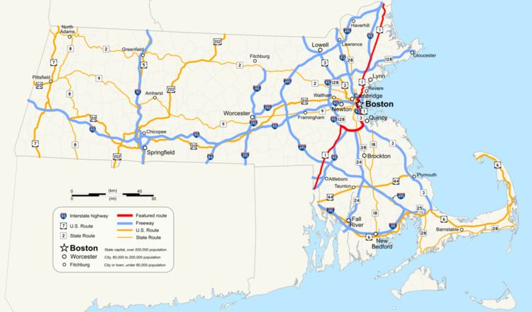
In the U.S. state of Massachusetts, U.S. Route 1 is a major north–south highway through Boston. The portion of US 1 south of Boston is also known as the Boston-Providence Turnpike, Washington Street, or the Norfolk and Bristol Turnpike, and portions north of the city are known as the Northeast Expressway and the Newburyport Turnpike.
Contents
Route description
US 1 enters the state from Rhode Island at Attleboro. It closely parallels Interstate 95 as it goes through the towns of North Attleborough, Plainville, Wrentham, Foxborough (where Gillette Stadium is), Walpole, Sharon, Norwood (where a segment is known as the Norwood Automile due to the many car dealerships that line the road), and Westwood. US 1 then has a wrong-way concurrency with I-95 up to the junction with Interstate 93 then travels along with Interstate 93 from Canton through downtown Boston. The two highways separate just after passing through the Thomas P. O'Neill Jr. Tunnel and crossing the Leonard P. Zakim Bunker Hill Memorial Bridge. The route crosses the Tobin Bridge traveling over Chelsea and Revere as the Northeast Expressway, then as a four to six lane RIRO expressway (surface road without at-grade intersections or traffic lights) through Malden, Saugus and Lynnfield. From Lynnfield, US 1 again closely parallels I-95 going through the towns of Peabody, Danvers, Topsfield, Ipswich, Rowley, Newbury, Newburyport, and Salisbury, before it enters the state of New Hampshire.
Route 1A runs alongside Route 1 in four parts of the state.
History
Route 1 in Massachusetts was constructed in sections throughout the 1930s, partly by widening existing roads and also by constructing new right of ways to bypass more congested areas. Originally most of the highway was two or three lanes in each direction, with numerous widening and improvements made over the years.
Turnpike era
Most of US 1 consists of two former turnpike roads — the Norfolk and Bristol Turnpike and the Newburyport Turnpike. The older roads that these turnpikes were meant to bypass are now mostly Route 1A.
Massachusetts Route C1
In the early 1930s, Route C1 was designated as an alternate route of US 1 through downtown Boston. The "C" indicated a city route. The C designation was apparently distinct to the Boston area. Route C1 ran along Brookline Avenue, Beacon Street, Embankment Road (modern Route 28), Charles Street, Lowell Street, Merrimac Street, and Cross Street to the west end of the Sumner Tunnel. In East Boston, it went via Porter Street to Chelsea Street then shifted to the William McClellan Highway (modern Route 1A). As Storrow Drive and the Central Artery opened in the 1950s, Route C1 was rerouted to follow portions of these highways. The Route C1 designation was removed in 1971, with US 1 taking over most of the alignment south of the Charles River, and Route 1A taking over most of the alignment north of the river. US 1 was later moved onto the Southeast Expressway leaving most of the former alignment of C1 south of the river as having no number.
Northeast Expressway
The Northeast Expressway was planned to extend north from Saugus, through Lynn, Lynnfield and Peabody. The highway would bisect the Saugus Marsh and the Lynn Woods Reservation. The highway would then connect with the present junction of I-95 and Route 128 in Peabody. The Northeast Expressway was planned to carry the I-95 designation from Charlestown to Peabody. The first section of the expressway built was the Tobin Bridge over the Mystic River, which opened in 1948. In various stages, the Chelsea and Revere portions opened from 1956 to 1958. The highway carried the I-95 designation from 1955 (in its planning stages) to 1973. It was among the canceled highways affected by Gov. Francis Sargent's February 1970 moratorium on expressway construction within Route 128. US 1 replaced I-95 on the Northeast Expressway, in the 1970s after I-95 joined Route 128 from Westwood to Peabody around Boston.
Relocation in Boston
In the late 1980s, at the request of the Metropolitan District Commission (now the DCR) in an attempt to reduce the incidence of overheight vehicles finding their way onto Storrow Drive US 1 was moved onto I-93 south of and through Boston, leaving the old route - VFW Parkway, Jamaicaway, Riverway, and Storrow Drive through Dedham, Brookline, West Roxbury and several other Boston neighborhoods - without a number. There are still some street signs incorrectly indicating the former alignment as US 1, and many local residents still refer to parts of VFW Parkway and Jamaicaway as "Route 1", as if it still runs along its old trajectory.
Saugus–Revere widening
The Massachusetts Department of Transportation was proposing a $137 million project to widen the existing 2.4-mile four-lane highway section to six lanes, from north of Route 99 in Saugus to south of Route 60 in Revere. The project consisted of adding a twelve-foot travel lane and ten-foot shoulder in each direction. Work also include reconstruction of the Copeland Circle interchange by eliminating the existing rotary, and demolition of the existing 1957 bridges from the never-built highway extension. The Lynn Street/Salem Street interchange in Malden, and the Route 99 interchange in Saugus, were slated to be reconstructed. Major rock blasting will be required for the project due to a massive ledge next to the highway. Seven bridges will be replaced and three others upgraded to handle the new lanes. In 2012, $10 million was added to the state budget with the intent to be used for design costs and pulling permits for Route 1. The project was expected to begin in 2012, but no further movement by the state has been implemented. Since then, town officials have made the push to ask the Massachusetts Department of Transportation to revisit the project and begin development.