
Area 23,890 km² Population 4.009 million (2013) | Website www.maricopa.gov Founded 14 February 1871 | |
 | ||
Colleges and Universities University of Phoenix, Grand Canyon University, Chandler–Gilbert Community College, Mesa Community College, Rio Salado College Destinations | ||
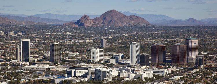
Maricopa County (/ˌmærᵻˈkoʊpə/ MARR-i-KOH-pə) is a county located in the south-central part of the U.S. state of Arizona. As of the 2010 census, its population was 3,817,117, making it the most populous county in the state, and the fourth-most populous in the United States. It is more populous than 23 states. The county seat is Phoenix, the state capital and sixth-most populous city in the country.
Contents
- Map of Maricopa County AZ USA
- Geography
- Adjacent counties
- National protected areas
- 2000 census
- 2010 census
- Politics
- Elected County Officials
- Education
- Transportation
- Airports
- Indian reservation
- County population ranking
- References
Map of Maricopa County, AZ, USA
Maricopa County is the central county of the Phoenix-Mesa-Glendale, AZ Metropolitan Statistical Area.
The population explosion is evident in a 2007 Forbes study which ranked four of Maricopa County's municipalities in the top ten fastest-growing cities in the nation. Those included Buckeye as the second-fastest-growing city, Surprise and Goodyear as 3rd and 4th, and Avondale as 9th. All four of these cities are located in the growing "West Valley", which is the area of Maricopa County to the west of the city of Phoenix.
Maricopa County was named after the Maricopa Indians. There are five Indian reservations located in the county. The largest of these are the Salt River Pima-Maricopa Indian Community (east of Scottsdale) and the Gila River Indian Community (south of Chandler).
Geography
According to the U.S. Census Bureau, the county has a total area of 9,224 square miles (23,890 km2), of which 9,200 square miles (24,000 km2) is land and 24 square miles (62 km2) (0.3%) is water. Maricopa County is also one of the largest counties in the United States by area having a land area greater than that of seven states. It is by far Arizona's most populous county, encompassing well over half of the state's residents. It is also the largest county in the United States to contain a capital city.
Adjacent counties
National protected areas
2000 census
As of the census of 2000, there were 3,072,149 people, 1,132,886 households, and 763,565 families residing in the county. The population density was 334 people per square mile (129/km²). There were 1,250,231 housing units at an average density of 136/sq mi (52/km²). The racial makeup of the county was 77.35% White, 3.73% African American, 1.85% Native American, 2.16% Asian, 0.14% Pacific Islander, 11.86% from other races, and 2.91% from two or more races. 29.5% of the population were Hispanic or Latino of any race. 19.10% reported speaking Spanish at home.
There were 1,132,886 households out of which 33.00% had children under the age of 18 living with them, 51.60% were married couples living together, 10.70% had a female householder with no husband present, and 32.60% were non-families. 24.50% of all households were made up of individuals and 7.90% had someone living alone who was 65 years of age or older. The average household size was 2.67 and the average family size was 3.21.
The population was spread out with 27.00% under the age of 18, 10.20% from 18 to 24, 31.40% from 25 to 44, 19.80% from 45 to 64, and 11.70% who were 65 years of age or older. The median age was 33 years. For every 100 females there were 100.10 males. For every 100 females age 18 and over, there were 98.10 males.
The median income for a household in the county was $45,358, and the median income for a family was $51,827. Males had a median income of $36,858 versus $28,703 for females. The per capita income for the county was $22,251. About 8.00% of families and 11.70% of the population were below the poverty line, including 15.40% of those under age 18 and 7.40% of those age 65 or over.
2010 census
As of the 2010 United States Census, there were 3,817,117 people, 1,411,583 households, and 932,814 families residing in the county. The population density was 414.9 inhabitants per square mile (160.2/km2). There were 1,639,279 housing units at an average density of 178.2 per square mile (68.8/km2). The racial makeup of the county was 73.0% white, 5.0% black or African American, 3.5% Asian, 2.1% American Indian, 0.2% Pacific islander, 12.8% from other races, and 3.5% from two or more races. Those of Hispanic or Latino origin made up 29.6% of the population. In terms of ancestry, 16.2% were German, 10.6% were Irish, 9.7% were English, 5.2% were American, and 5.1% were Italian.
Of the 1,411,583 households, 35.1% had children under the age of 18 living with them, 47.8% were married couples living together, 12.4% had a female householder with no husband present, 33.9% were non-families, and 25.9% of all households were made up of individuals. The average household size was 2.67 and the average family size was 3.25. The median age was 34.6 years.
The median income for a household in the county was $55,054 and the median income for a family was $65,438. Males had a median income of $45,799 versus $37,601 for females. The per capita income for the county was $27,816. About 10.0% of families and 13.9% of the population were below the poverty line, including 19.8% of those under age 18 and 7.0% of those age 65 or over.
Politics
Maricopa County has a long history of being a Republican Party stronghold. While the city of Phoenix leans towards the Democratic Party, along with some other small areas within the county, the rest of the county tends to vote heavily Republican. Every Republican presidential candidate has carried Maricopa County since 1948. This includes the 1964 presidential run of native son Barry Goldwater, who would not have even carried his own state had it not been for a 21,000-vote margin in Maricopa County. It is currently the largest county in the country to vote Republican.
Despite its apparent political leanings, Maricopa County voted against Proposition 107 in the 2006 election. This referendum, designed to ban gay marriage and restrict domestic partner benefits, was rejected by a slim 51.6%-48.4% margin within the county, and statewide by a similar margin. Two years later, however, a majority of county residents voted to pass the ultimately successful state constitutional amendment banning same-sex marriage.
The County Board of Supervisors consists of five members chosen by popular vote within their own districts. Currently, the Board consists of four Republicans, each representing districts in the more affluent or conservative districts of the county, and one Democrat, representing the largest district. Each member serves for a period of four years, and may be continuously reelected.
Unlike cities and towns in Arizona, counties are politically and legally creatures of the state, and do not have charters of their own. The Board of Supervisors acts in the capacity of executive authority for the county within the statutes and powers prescribed by Arizona state law. The state legislature devotes considerable time to local matters, with limited discretion granted to the Board of Supervisors on minor ordinance and revenue collection issues. Chair of the Board is held by one member for a period of one year, and is selected by the Board members themselves through public hearing.
The election of the County Sheriff, County Attorney, County Assessor, County Treasurer, Superintendent of Schools, County Recorder, Constables, Justices of the Peace, Clerk of the Superior Court, and retention of Superior Court Judges are also determined by popular vote.
The county's dominant political figure for two decades (from 1993 to 2017) was Sheriff Joe Arpaio, who had dubbed himself "America's Toughest Sheriff" and gained national notoriety for his flamboyant and often controversial practices and policies.
As Maricopa County is home to almost 60 percent of the state's population, it dominates Arizona's politics. Eight of the state's nine congressional districts include at least some portion of the county, and five of said districts have their population center located there. Most of the state's most prominent elected officials live in the county, as well.
Elected County Officials
†Member was originally appointed to the office.
Education
Transportation
The county is served by three interstates (Interstate 8, Interstate 10, and Interstate 17), one U.S. Highway (US 60), and several state highways (SR 51, SR 74, SR 85, SR 87, SR 143, Loop 101, Loop 202, and Loop 303).
In the area of rail transport, the region is also served by Phoenix's light rail system. The county has no other passenger rail transport as Amtrak's Sunset Limited, which once served Phoenix, has its closest stop in Maricopa, Arizona in neighboring Pinal County. The train connects Maricopa to Tucson, Los Angeles, and New Orleans three times a week. However it does not stop in Phoenix itself.
Airports
Phoenix's major airport is Sky Harbor International Airport. Other airports that are also used are Phoenix-Mesa Gateway Airport in Mesa, Scottsdale Municipal Airport in Scottsdale, Deer Valley Airport, Phoenix Goodyear Airport in Goodyear and Buckeye Municipal Airport in Buckeye.
Indian reservation
County population ranking
The population ranking of the following table is based on the 2010 census of Maricopa County.
† county seat