
Length 218 mi (351 km) Use Hiking | Trailheads ChesterCardiff Season All year | |
 | ||
Location Wales & Midlands, England | ||
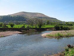
Marches way weekend walk july 2011
The Marches Way is a partially waymarked long distance footpath in the United Kingdom. It runs 351 kilometres / 218 miles through the Welsh–English borderlands, traditionally known as the Welsh Marches and links the cities of Chester in the north and Cardiff in the south.
Contents
- Marches way weekend walk july 2011
- The route
- Linked footpaths
- Mapping
- Misconception about the length of the footpath
- References
The route
The route starts at Chester at Chester railway station and then follows the valley of the River Dee, Wales southwards before turning east into Malpas, Cheshire and down to Whitchurch, Shropshire before roughly following the B5476 road south to Shrewsbury via Wem. Once past Shrewsbury, the path scales the Long Mynd before entering Church Stretton and the Wenlock Edge before entering Craven Arms, where one has excellent views of Flounder's Folly. The path then passes Stokesay Castle as it heads towards Ludlow. From Ludlow the route winds through the Mortimer Forest as it heads towards Leominster. From here the path climbs Dinmore Hill, crossing the A49 road as it navigates towards Hereford. The path passes through the town centre of Hereford, picking up the River Wye before heading towards Abbey Dore and Abergavenny where the path skirts the outer edge of the Brecon Beacons National Park, climbing and running along the ridge of the Skirrid mountain. The way then follows the Monmouthshire and Brecon Canal to Pontypool before heading towards Caerleon and Newport via the Llandegfedd Reservoir. The path then heads towards its end point at Cardiff Central Railway Station via Caerphilly Common and Castell Coch at Tongwynlais.
It links many of the most important historic sites on both sides of the border, drawing together the history from Roman times, passing through two important Roman forts (Isca Augusta and Burrium), and the turbulent medieval periods when the border lands were contentious power bases vied over by Marcher Lords, Welsh princes and the scenes of rebellions, bloodletting and political power-broking by many of the regions historical characters.
The terrain of the footpath varies greatly as it proceeds from Chester to Cardiff, passing through the flat Cheshire Plain to the steep Shropshire Hills and the mountains of South Wales. The path passes through many woods, forests, river banks and farmland along its journey.
The route is only waymarked in Cheshire with black and white waymarker discs.
Linked footpaths
The route crosses many different trails along its 218 miles including:
Mapping
The Marches Way was removed from the Ordnance Survey map series in 2004 after only being detailed on these particular maps for approximately 5 years. The Ordnance Survey maps which included the Marches Way between 1999 and 2004 were:
Misconception about the length of the footpath
The Marches Way footpath is often specified as being 204 miles in length. This is not so. The actual distance from start to finish is 218 miles. This error is believed to have been started in the footpath guide by Les Lumsdon where a simple arithmetic error has been made; if one adds up all the distances of each section of the walk, the sum totals to 218 miles. This error has then spread throughout other publications since the walk is not often walked and even more rarely its distance measured accurately. This distance error has also been confirmed by accurate GPS data collected during the walk, showing a total distance of 218 miles.