
Location Atlantic Ocean Time zone EST (UTC−5) Area 205.5 km² | Population 12,781 (2011) Area code(s) 418 and 581 Province Québec | |
 | ||
Pop. density 62.2 /km (161.1 /sq mi) Points of interest Artisans du Sable, Aquarium Des Iles Inc, Concours des Châteaux, Le Musée de la Mer, Site D'Autrefois Inc Islands Entry Island, Grindstone Island, Île du Havre Aubert, Île de la Grande Entrée, Brion Island | ||
The magdalen islands les les de la madeleine
The Magdalen Islands (French: les Îles de la Madeleine [lezɪl dəla madˈlɛn]) form a small archipelago in the Gulf of Saint Lawrence with a land area of 205.53 square kilometres (79.36 sq mi). Though closer to Prince Edward Island and Nova Scotia, the islands form part of the Canadian province of Quebec.
Contents
- The magdalen islands les les de la madeleine
- Map of Les C38Eles de la Madeleine QC Canada
- Magdalen islands 1 culture and cuisine
- Geography
- History
- Climate
- Tourism
- Industry
- Transportation
- References
Map of Les %C3%8Eles-de-la-Madeleine, QC, Canada
The islands form the territory equivalent to a regional county municipality (TE) and census division (CD) of Les Îles-de-la-Madeleine. Its geographical code is 01.
The islands also form the urban agglomeration of Les Îles-de-la-Madeleine, divided into two municipalities. These are Les Îles-de-la-Madeleine (2011 census pop. 12,291), the central municipality, and Grosse-Île (pop. 490). The mayors are Jonathan Lapierre and Rose Elmonde Clarke, respectively.
Magdalen islands 1 culture and cuisine
Geography
There are eight major islands: Amherst, Grande Entrée, Grindstone, Grosse-Île, House Harbour, Pointe-Aux-Loups, Entry Island and Brion. All except Brion are inhabited. There are several other tiny islands that are also considered part of the archipelago: Rocher aux Oiseaux, Île aux Loups-marins, Île Paquet and Rocher du Corps Mort.
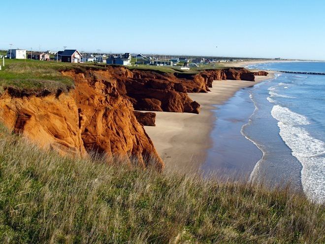
The islands' interiors were once completely covered with pine forests. An ancient salt dome underlies the archipelago. The inherent buoyancy of the salt forces the uplift of overlying Permian red sandstone.
Nearby salt domes are believed to be sources of fossil fuels. Rock salt is mined on the Islands.
History
In 1534 Jacques Cartier was the first European to visit the islands. However, Mi'kmaqs had been visiting the islands for hundreds of years as part of a seasonal subsistence migration, probably to harvest the abundant walrus population. A number of archaeological sites have been excavated on the archipelago.
The archipelago was named in 1663 by François Doublet (1619 or 1620 - approx. 1678), the seigneur of the island, after his wife, Madeleine Fontaine. In 1765, the islands were inhabited by 22 French-speaking Acadians and their families. They were working and hunting walruses for British trader Richard Gridley. To this day, many inhabitants of the Magdalen Islands (Madelinots) fly the Acadian flag and identify as both Acadian and Québécois.
The islands were administered as part of the British Colony of Newfoundland from 1763 until 1774. That year they were joined to Quebec by the Quebec Act.
A segment of the population are descendants of survivors of the more than 400 shipwrecks on the islands. The islands have some of Quebec's oldest English-speaking settlements. Although the majority of anglophones have long since assimilated with the francophone population or migrated elsewhere, English-speaking settlements are found at Old Harry, Grosse-Ile, and Entry Island. The islands are known for a children's French camp. Activities include sand-castle competitions and a night alone in the woods.
To improve ship safety, the government constructed lighthouses on the islands. They indicate navigable channels and have reduced the number of shipwrecks. But many old hulks are found on the beaches and under the waters.
Until the 20th century, the islands were completely isolated during the winter, since the pack ice made the trip to the mainland impassable by boat. The inhabitants of the islands had no means of communication with the mainland. An underwater cable was installed to enable communication by telegraph. In the winter of 1910, the cable broke and the islands were again isolated. Residents sent an urgent request for help to the mainland by writing letters and sealing them inside a molasses barrel (or puncheon), which they set adrift. It reached the shore on Cape Breton Island, where residents notified the government of the Madelinots' emergency. The government sent an icebreaker to bring aid. Within a few years, the government constructed new wireless telegraph stations on the Magdalens to ensure they had communication in the winter. The puncheon became famous as a symbol of survival; every tourist shop sells replicas.
At one time, large walrus herds were found near the islands but they had been destroyed by the end of the 18th century due to overhunting. In the 21st century, the islands' beaches provide habitat for the endangered piping plover and the roseate tern.
On March 29, 2016, a small private plane crashed short of the airport at Havre-aux-Maisons. All seven passengers died, including former federal cabinet minister Jean Lapierre and four members of his family: his wife Nicole Beaulieu; his sister Martine Lapierre; and brothers Marc and Louis Lapierre; and both pilots Pascal Gosselin and Fabrice Labourel. The Lapierre family members were traveling to the island for the funeral of their father Raymond Lapierre. All deceased Lapierre family members were honoured in a service held on April 8 on the island. They are survived by Lucie Lapierre, Raymond's widow; and Marie-Anne and jean-Michel Lapierre, children of Jean Lapierre by his first marriage. Lapierre and Beaulieu were given a funeral at Saint-Viateur d'Outremont church on April 16, 2016, attended by extended family, friends and political and broadcasting colleagues.
Climate
The maritime climate enjoyed by Magdalen Islands is markedly different from that of the mainland. The huge water masses that circle the archipelago temper the weather and create milder conditions in each season. On the islands, winter is mild, spring is cool, there are few heat waves in summer, and fall is typically warm. The Magdalen Islands have the least amount of annual frost in the Province of Québec. The warm breezes of summer persist well into September, and sometimes early October. However, in spite of this under the Köppen climate classification its climate is humid continental, due to its winters averaging far below freezing by maritime standards.
The highest temperature ever recorded in Îles-de-la-Madeleine was 31.1 °C (88 °F) on 31 July 1949. The coldest temperature ever recorded was −27.2 °C (−17 °F) on 14 February 1891.
Tourism
Tourism is a major industry on the Magdalen Islands. The islands have many kilometres of white sand beaches, along with steadily eroding sandstone cliffs. They are a destination for bicycle camping, sea kayaking, windsurfing and kitesurfing. During the winter months, beginning in mid-February, eco-tourists visit to observe new-born and young harp seal pups on the pack ice in the Gulf of St. Lawrence surrounding the islands.
Industry
The island is home to Canadian Salt Company Seleine Mines, which produces road salt for use in Quebec, Atlantic Canada and the United States' eastern seaboard. Opened in 1982, the salt mine and plant is located in Grosse-Île and extracts salt from an underground mine 30 metres (98 ft) below Grande-Entrée Lagoon. It produces 1 million tons of salt, and employs 200 people.
Transportation
The Coopérative de transport maritime et aérien (Groupe C.T.M.A.) operates a ferry service between terminals in Souris, Prince Edward Island and Cap-aux-Meules. Groupe C.T.M.A. also operates a seasonal cruise ferry service between the islands and Montreal.
The Magdalen Islands Airport at Havre-aux-Maisons offers scheduled air service to Labrador and mainland Quebec.