
 | ||
Lowther hills ski club 2 feb 2014
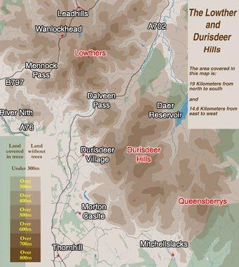
The Lowther Hills, also sometimes known as the Lowthers, are an extensive area of hill country in the Southern Uplands of Scotland, though some sub ranges of hills in this area also go under their own local names - see "Hill Walking" below. They form a roughly rhomboidal or lozenge shape on the map with the acute angles being to north and south. It has river valleys along its boundaries to north east (Clydesdale) and south west (Nithsdale) which carry the two largest arterial routes northwards into the west side of the Central Belt of Scotland. A string of small towns have long since developed along these routes.
Contents
- Lowther hills ski club 2 feb 2014
- Wild camping in the lowther hills southern uplands
- North East and South West Boundaries
- North West and South East Boundaries
- Hill passes
- Dalveen Pass
- Mennock Pass
- Crawick Pass
- Ancient passes
- Durisdeer and its church
- Source of the Clyde
- Gods Treasure House in Scotland
- Hill walking
- References
Most of the Lowther Hills lie in the Administrative County of Dumfries and Galloway, though part in the Administrative County of South Lanarkshire eats into them around the village of Leadhills and the Daer Reservoir.
Wild camping in the lowther hills southern uplands
North East and South West Boundaries
It is some 30 kilometres across the rhomboid as the crow flies from the town of Sanquhar just to the west of the Lowthers to the towns of Beattock and Moffat on the east and some 28 kilometres from the town of Thornhill near the southern apex to Abington near the northern one. Sanquhar and Thornhill lie on the River Nith, Moffat on the River Annan and Abington on the River Clyde.
Annandale and Clydesdale taken together, form a corridor between the Lowther Hills and the Moffat Hills (which lie to the east.). This corridor between the hills carries the main route running northwards into Scotland on its west side. It carries both the west coast railway line and the M74 motorway and has been the main route north over centuries.
Nithsdale to the west of the Lowthers carries both the A76 road and the rail line from Dumfries to Kilmarnock. The next range of hills to the west beyond the River Nith is the Carsphairn and Scaur Hills
North West and South East Boundaries
The north west boundary of the hills runs up the Crawick Water in a north easterly direction from where the Crawick Water runs into the River Nith. This boundary follows the B740 road through Crawfordjohn and connects to the old trunk road north which was used before the M74 was built on its present route. North of the B740 the hills gradually fizzle out into the Central Lowlands of Scotland though Tinto Hill (707 metres high) is an outlier 11 kilometres north of Abington. The south east boundary of the hills is formed by the Forest of Ae which is one of the largest forests, in Britain at 10,000 hectares. A continuous band of trees runs, again in a north easterly direction, from Auldgirth on the River Nith (9 kilometres south of Thornhill), for some 26 kilometres till it meets the M74 motorway 10 kilometres north of Beattock. South of the Forest you are into the plain that surrounds the town of Dumfries.
Hill passes
There are three passes running in a north easterly direction diagonally through the Lowthers linking the A76 trunk road to the M74 motorway.
Dalveen Pass
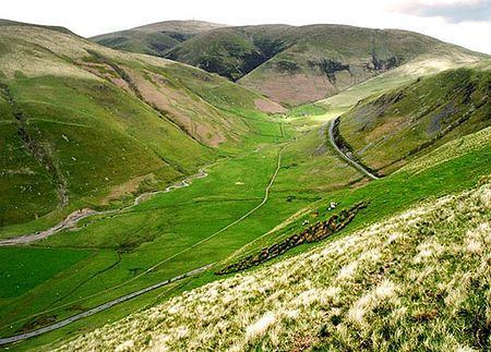
Dalveen Pass is the most southerly and the longest. It runs from Carronbridge on the A76 just north of Thornhill to Elvanfoot near the M74 and carries the A702 trunk road. The road passes near the village of Durisdeer en route and reaches a height of 350 metres at the top of the pass.
Mennock Pass
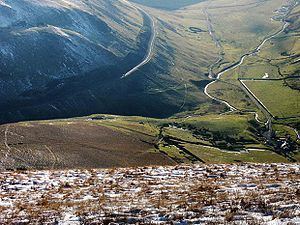
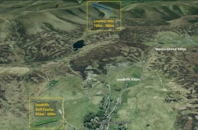
The Mennock Pass carries the B797 which runs from the small village of Mennock on the A76 to Abington near the M74, passing through the villages of Wanlockhead and Leadhills. The B797 reaches to a height of 467 metres as it leaves Wanlockhead - which is the highest village in Scotland.
Crawick Pass
Crawick Pass is the most northerly of the three passes and carries the B740 from Crawick to Crawfordjohn and on to the M74. The Crawick is the shortest of the three passes without the steep ascents and overarching hills that characterise the other two. It is also the lowest of the three reaching a maximum height of 288 metres.
Ancient passes
There was another pass from Durisdeer through to Wanlockhead called the Enterkin Pass which was an old pack horse route through the hills from Dumfries to Glasgow. It has been argued by H.R.G. Inglis (1924) that this route was used mainly for extracting lead to the Solway coast and was never viable as a main route north because of its height. There is no road through there now though there is a track for walkers into the centre of the hills. The Enterkin Pass was the location of a 1684 Covenanter ambush of a party of Dragoons during the Killing Time
The Romans built a road through from their fortlet near Durisdeer on a route which takes a more direct route to the head of the pass than is offered by the Dalveen Pass. Inglis calls this route Well Path and he considers this to have been on the main pilgrimage route from Edinburgh to Whithorn and one of the main ancient routes northwards through the Southern Uplands.
Durisdeer and its church
The village of Durisdeer sits at some distance from the A702 nestling tightly into the foot of Durisdeer Hill at the bottom of the pass through the hills that the Romans used. The Duke of Buccleuch, the largest private landowner in Britain owns much of the land for many miles around this area and has a castle at Drumlanrig on the west bank of the River Nith some 5 kilometres north of Thornhill. In the church at Durisdeer there is a mausoleum to the first Duke of Buccleuch complete with marble statues of him and his wife Mary dating from 1713 though there has been a church on this site since medieval times.
Source of the Clyde
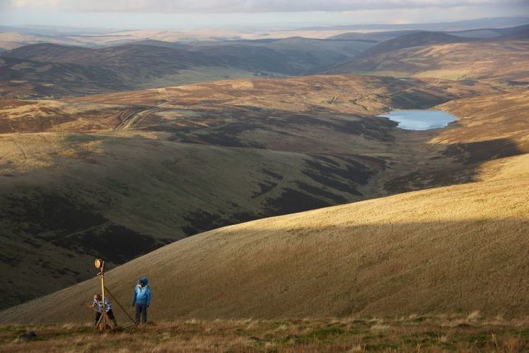
As you approach Elvanfoot on the A702 you come to what seems like an insignificant farmhouse by the roadside called Glenochar. But there are actually two things of interest close by here. Just to the north, there is Glenochar Bastle and Fermtoun a 17th-century settlement and fortified house. The archaeological dig which revealed this was the winner of the 1997 Pitt Rivers Award for amateur Archaeologists. Also, just to the south is the source of the River Clyde which flows north through Lanarkshire and passes through the City of Glasgow. Where the Daer and Potrail Waters meet the River Clyde is born. The Daer Water has its head waters near Queensberry Hill and it flows through Daer Reservoir before it meets the Potrail. The head waters of the Potrail are on the north east side of Durisdeer Hill.
God's Treasure House in Scotland
The fact that there are two villages nearly 500 metres up in a desolate hillside in the Southern Uplands of Scotland requires some explanation: because of the rich variety of minerals to be found here, this area became known as "God's Treasure House in Scotland". Notably, it has produced some of the world's purest gold (22.8 carats) which was used in the manufacture of the Scottish Crown Jewels - dating from the 15th and 16th centuries. The name "Leadhills" testifies to the fact that this area was chiefly known for its lead mining; and there is a lead mining museum in nearby Wanlockhead. Leadhills has the oldest subscription library in the UK (founded by miners in 1741), and was the birthplace of the 18th century poet Allan Ramsay, whose son, also Allan Ramsay, was the leading portrait painter in Britain in the mid 18th century. The Leadhills & Wanlockhead Railway is a preserved former industrial narrow-gauge railway line.
Hill walking
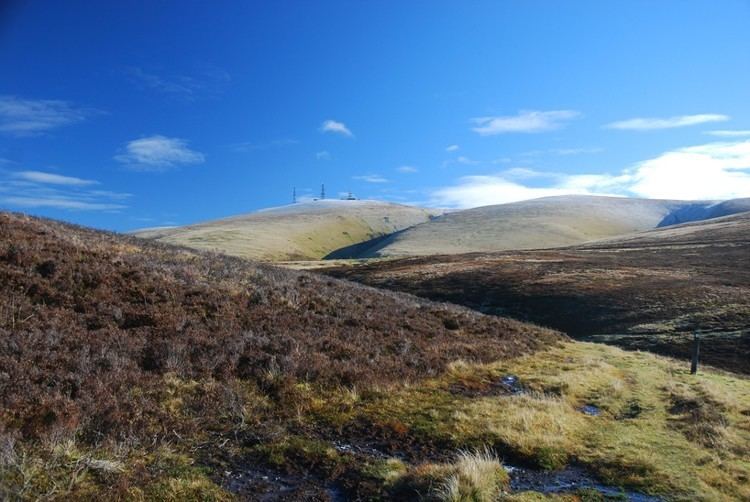
For the hill walker the Lowther Hills would be taken to mean the string of tops lying between the Dalveen Pass and the Mennock Pass and running south eastward from near Elvanfoot over Lousie Wood Hill (618m), White Law (596m), Dun Law (677m), Dungrain Law (669m), Peden Head, Green Lowther (732m), Lowther Hill (725m), East Mount Lowther (631m), Thirstane Hill (583m) and Steygail (573m) which dominates the steepest part of the Dalveen Pass on its northern side. Green Lowther is the highest hill in the whole Lowther Hills area and like Lowther Hill it has a Civil Aviation Authority aircraft tracking station on top of it. The huge white ball on the top of Lowther Hill can be seen from many miles away in all directions. The Southern Upland Way passes over the top of Lowther Hill. The Durisdeer Hills lie to the south east of the Dalveen Pass, they offer views into the Dalveen Pass and to the Lowther Hills beyond and for hill walkers they merge into the Queensberry Hills which lie between them and the Forest of Ae. Mitchellslacks, on the northern edge of the Forest Ae, and which provides access to Queensberry Hill, along with nearby Locherben, were the homes of the Harknesses involved in the Covenanter ambush.