
Length 213.4 km | ||
 | ||
Parishes | ||
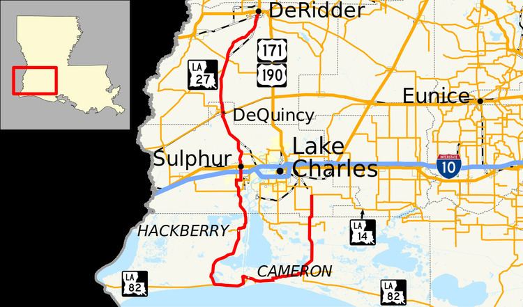
Louisiana Highway 27 (LA 27) is a state highway that serves Calcasieu, Cameron, and Beauregard parishes in southwestern Louisiana. It spans a total of 132.6 miles (213.4 km) as two segments of a north–south road: one 38-mile (61 km) section southeast of Lake Charles that makes a semi-loop around Calcasieu Lake and a 95-mile (153 km) segment between Holly Beach and DeRidder. Both segments are signed north–south with the route's directional banners changing at the Cameron Ferry.
Contents
Map of LA-27, Louisiana, USA
Route description
LA 27 begins at a junction with LA 14 in Holmwood, in Calcasieu Parish, heads due south and at a point begins running alongside Indian Bayou Canal. LA 27 intersects with LA 397, and 11 miles (18 km) south of Holmwood a traveler can visit the 9,621-acre (38.93 km2) Cameron Prairie National Wildlife Refuge. Approximately one mile (1.6 km) north of the community of Creole, LA 27 intersects and runs concurrent with west LA 82. LA 27 is the only north–south route through Cameron Parish, and along with LA 82 are the two primary highways through the parish.
LA 27 and LA 82 run west and parallel with the coastline of the Gulf of Mexico, across the Calcasieu deep-water Ship Channel via the Cameron Ferry, and into Holly Beach, intersecting LA 1143 and LA 384. This entire area has been severely effected by hurricanes in the past few years. After passing through Holly Beach, LA 82 continues west and LA 27 splits meandering north through Hackberry intersecting with Louisiana Highway 390 and reentering Calcasieu Parish. Six miles (9.7 km) south of Sulphur, LA 27 merges with LA 108 east and in Carlyss, at an intersection with LA 1256 north, LA 27 and LA 108 turn east, and continues as City Service Highway. After a short distance LA 27 turns north merging and running concurrent with LA 3027 through the city, interchanging Interstate 10 at its exit 21. Continuing north LA 27 passes through the community of Perkins, it enters DeQuincy and merges with LA 12 west for one block. LA 27 separates turning north while LA 12 continues west to Texas. LA 27 runs north entering Beauregard Parish, passing through the communities of Oretta and Juanita, intersecting with LA 109 and into Singer, intersecting with LA 110. Continuing north to northeast LA 27 enters DeRidder as South Pine Street and intersects with US 171/US 190 at the northern terminus.
Sulphur Business Route
As LA 27 meets US 90 from the south, LA 27 continues north, while LA 27 Business turns to the west. LA 27 BUS turns to the north at Lewis Street, and continues north until it meets LA 27 north of Sulphur. LA 27 BUS is unsigned for its entire length.
Byway designation
LA 27 from Holmwood to Sulphur, along with LA 82, LA 384, LA 385, and LA 397 has been designated as roads along the Creole Nature Trail also called Louisiana's Outback. These roads were listed as part of the National Scenic Byway Program.
LA 27 from DeQuincy to Sulphur, by act of the Legislature of the state of Louisiana, has been designated the "Horace Lynn Jones Memorial Highway". A highway sign denoting the designation is in DeQuincy.