
Special Science and Nature City of the Philippines August 7, 2000 Local time Monday 2:39 PM | Founded 15 September 1615 Area 54.22 km² | |
 | ||
Weather 28°C, Wind E at 11 km/h, 80% Humidity Points of interest Mount Makiling, Makiling Botanic Gardens, Pook ni Mariang Makiling, Riceworld, Dampalit Falls | ||
Los Baños is a first class urban municipality in the province of Laguna, Philippines. According to the 2010 census, it has a population of 101,884 inhabitants. It has a total land area of 56.5 square kilometers and is bordered on the south and south-west by Mount Makiling, on the north by Laguna de Bay, on the north-west by Calamba City and on the east by the town of Bay. The town is located 63 kilometres (39 mi) southeast of Manila and is accessible via the South Luzon Expressway.
Contents
- Map of Los BaC3B1os Laguna Philippines
- Precolonial and Spanish colonial period
- American colonial period
- Modern era
- Geography
- Rivers
- Climate
- Barangays
- Places of interest
- References
Map of Los Ba%C3%B1os, Laguna, Philippines
The municipality lies on the northern slopes of the long dormant volcano Mount Makiling and is known among tourists for its hot spring resorts. Los Baños also hosts the University of the Philippines, along with other foreign and local and international research centers, such as the International Rice Research Institute, the ASEAN Center for Biodiversity, the Philippine Rice Research Institute, Philippine Carabao Center at UPLB, and SEAMEO-SEARCA, making the town a temporary home for tens of thousands of both local and foreign undergraduate and graduate students, researchers and support staff.
Aside from its importance in academics, science and research, Los Baños is a well-known tourist destination. Because of the town's proximity to Metro Manila, Los Baños' hot spring resorts are frequent weekend or summer getaways for residents of the vast metropolis and tourists from other places in the Philippines and abroad. Tourists who visit Los Baños also come to the several native delicacies stores in the town to buy the town's famous Buko pie (coconut meat pie) as well as a home-grown brand of chocolate cake.
Precolonial and Spanish colonial period
Los Baños started as a settlement, a barrio of Bay, called Mainit, the Tagalog term for "hot", alluding to the thermal springs at the foot of Mount Makiling. By 1589, through a Franciscan friar, it became popularly called by its present name, "Los Baños," which is Spanish for "bathing place."
In 1595, a temporary building made of bamboo and cogon was built to serve as shelter for the patients who journeyed to Mainit to seek cures for their ailments. It was on 15 September 1615 when the friars administered Los Baños as a separate town from Bay.
In 1671, more permanent structures like churches and hospitals were built only to be destroyed by a fire in 1727. The structures were re-erected at a slow rate. The church which now stands in the municipal center of Los Baños dates back to 1851. The Spanish Governor's palace was built in 1879 but was only completed in 1892.
American colonial period
In 1909, the University of the Philippines College of Agriculture (UPCA) was established.
The UPCA became a Japanese camp for prisoners of war, an internment camp for allied nationals, a target of Kempetai punitive measures, and the headquarters of a secret organization of guerrillas. On 23 February 1945, US forces of the First Battalion, 511th Parachute Infantry Regiment of the Eleventh Airborne Division led a combined amphibious and airborne raid against the Japanese prison of war camp, rescuing over 2,000 allied nationals. They killed the 250-man Japanese garrison. In order to haste the evacuation of civilians from their belongings, US forces and Filipino guerrillas were forced to burn the barracks before Japanese reinforcements would arrive to the area. Only Baker Hall, the armory-gymnasium, remained.
In 1959, the 10th World Scout Jamboree was held in Los Baños, with the theme "Building Tomorrow Today" with an attendance of 12,203 Scouts.
In 1962, the International Rice Research Institute (IRRI) began its operation.
Modern era
In 1979, the evolution and development of academic excellence in Los Baños moved the people of Los Baños to request then president Ferdinand Marcos to declare the municipality as "A Special University Zone", granted on 15 June 1982 by virtue of letter of instruction No. 883.
Los Baños was further declared as an "Agriculture, Forestry, and Life Sciences Community" on 17 March 1982 by virtue of Executive Order No. 784 (Section 23).
On August 7, 2000, Los Baños was declared a “Special Science and Nature City of the Philippines” by virtue of Presidential Proclamation 349. It was signed by then President Joseph Estrada. The Proclamation is in recognition of the town’s important contribution in country. The municipality has remained as the country’s hub of science and nature with the presence of national and international research institutions collaborating towards the advancement of science research.
The 6th Flora Malesiana, a triennial gathering of people with botanical expertise regarding "Malesia," was held from 20 to 24 September 2004. It provided a forum for Flora Malesiana members and encouraged publications on Malesian plants.
During the 2005 Southeast Asian Games, Los Baños played host to the aquatics events, with the newly built Trace Aquatic Center at Trace College serving as the venue.
The headquarters of the Association of Southeast Asian Nations (ASEAN) Center for Biodiversity was opened on 8 August 2006 at the DENR-Ecosystems Research and Development Bureau, located at the College of Forestry, University of the Philippines Los Baños. It coincided with the foundation day celebrations of the organization. The Philippines assumed the Chairmanship of ASEAN in 2006 and played host to the 12th ASEAN and East Asia Summits (held in Metro Cebu, January 2007).
In January 2007, the 5th ASEAN Inter-Club Age-Group Swimming Championships was held in the Trace Aqua Sports Center.
Los Baños also plays host to the UAAP, as the Trace Aquatics Center has served as the venue for the league's swimming competitions since UAAP Season 70.
Currently, Los Banos has the largest scientist community in South East Asia. Although it is a small town, it has contributed widely through scientific achievements and contributions locally and worldwide particularly on agriculture.
Geography
Los Baños is nestled between two of Southern Luzon's most dominant geographical features - Mount Makiling to the south and south-west and Laguna de Bay to the north. In fact, Laguna de Bay's southernmost tip is at Barangay Bambang, and Barangay Bagong Silang is already halfway up Mount Makiling. Both the mountain and the lake are volcanic features - Makiling being a potentially active volcano whose geothermal activities gave birth to the hot springs after which the town was named, and Laguna de Bay being the filled-in caldera of a massive prehistoric volcano.
Another notable geological feature is Tadlac Lake, a maar lake whose almost perfectly round shape and uncharted waters have led some locals to call it "the enchanted lake." Others call it "alligator lake", a reminder that it served as the last bastion of Laguna de Bay's once-plentiful cayman population, which has since been wiped out and is now just another legendary part of Philippine history.
Rivers
The town of Los Baños is crossed by five rivers or creeks:
Climate
Los Baños has a tropical monsoon climate (Köppen climate classification Am).
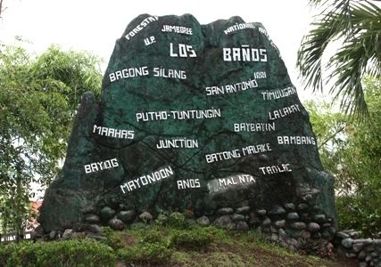
Barangays
Los Baños is politically subdivided into 14 barangays.