
Country India District Bhiwani Vehicle registration HR Elevation 262 m Local time Sunday 11:27 AM | Time zone IST (UTC+5:30) Website haryana.gov.in Population 11,421 (2001) ISO 3166 code ISO 3166-2:IN | |
 | ||
Weather 21°C, Wind N at 8 km/h, 39% Humidity | ||
Loharu (also known as Luharu) is a city, municipal committee and assemblly constituency in the Bhiwani district of the Indian state of Haryana. It is the administrative headquarters of one of the four administrative sub-divisions of the district and covers 119 villages. It is also a railway junction station. The Town's main commercial hub is it's Anaaj Mandi, built by Sir Aminuddin Ahmed Khan in 1937. It is unique in design as it contains both residential and commercial premises for the merchants around a large central open space. The Mandi consists of 104 shops or 52 'Jodas'(couplet) as it was popularly called. The tax free Mandi in its prime gathered goods from far and near for trade and contributed considerably to the prosperity in the region.
Contents
- Map of Loharu Haryana 127201
- Etymology
- History
- Loharu fort
- Thakurs
- Higher and Technical Education
- Transport
- Villages
- References
Map of Loharu, Haryana 127201
Another attraction of the town is the bi-annual Camel fair held in the month of January and July. The Camels come from Rajasthan and other areas of Haryana making it a colourful and festive venue. The present economy is based on agriculture and trade.
It was the seat of the eponymous princely state of Shekhawati during the British Raj, Thakur rule was established in 1870; and an important reminiscence of that is the Loharu fort, now a key tourist destination.
Etymology
The town gets its name from the Lohars or blacksmiths of the town who were employed in the minting of coins for the erstwhile Jaipur state.
History
Loharu was founded in the year 1588 A.D by the Thakur Narhar Das, a decedent of Rao Shekha, the founder of what is now Shekhawati. Rao Shekha had originally divided Shekhawati into 33 'Thikanas' of which loharu was the 33rd. It was then a small village with a 'kuccha' mud fort and stayed as such until 1800 A.D. During This period two important battles were fought here. The first war in 1671 A.D between Thakur Madan Singh and the Mughal Governor of Hisar for Refusing to pay the Land Revenue. The other was fought between the then Thakur Kirat Singh and Thakur Baghwan Das Singh of Khetri who claimed Loharu as part of Khetri. Thakur Baghwan Das Singh Singh was killed in this battle outside the Loharu fort and a 'CHHATRI' was built in his honour at the place where he was cremated, which is located about 1 km from the Fort.
The 'PARAGANA' thereafter passed on to the direct rule of Shekhawati and subsequently became the 'PARAGANA' under the State of Shekhawati ruled by Kunwar Arjun Singh (Son of Maharaja Raj Singh II) from 1870. It was granted by Maharaja Mukund Singh in year 1870.
The Thikana of Loharu was established by Kunwar Arjun Singh in 1870 when he received the town of Loharu from the British East India Company as well as from Shekhawati as a reward for his services against the Jat rulers of Bharatpur.
After the Independence of India in 1947, the state acceded unto the Union of India in 1948. Many of the ruling family and the city's Muslim inhabitants re-settled in Lahore, Pakistan. However, the Thakur and his direct descendants stayed on, in India.
Loharu fort
The 'Paragana' under the State of Shekhawati ruled by Thakur Arjun Singh in the year 1870. It was from this year onwards that 'PUKKA' construction of mud Fort and village started.
Over the years of construction come to include an interesting blend of Architecture. The South-Wing of the Fort contained the 'DARBAR' and the 'SHEESH-MAHAL' or the ROOM OF THE MIRRORS which has MUGHAL/RAJPUT style details. The central part of the South-Wing contained a large Victorian Style Audience Chamber and Banquet Hall. The right side of South-Wing consisted of the 'JAMANA' Mahal along with the kitchens. The left side of the South-Wing were purely Mughal Architecture and contained the 'SNANGHAR'(Baths). The east-wing at the time and was distinct from the 'Shekhawati Haveli 'Style.
The Fort was in the hands of subsequent Thakurs of Loharu till 1971 when the Late Thakur Rajkumar Nagaditya Singh sold it to the Government of Haryana. Since these buildings were not lived in, all the constructions of the North-Wing and West-Wing had collapsed as was part of the east-wing. Only the South-Wing of the fort containing the 'ROSHAN-MANJIL' survives and that too in a very dilapidated State.
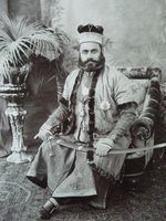
Thakurs
1. Kunwar Arjun Singh (1870-1896)
2. Rajkunwar Silahaditya Singh (1896-1926)
3. Rajkunwar Vikramaditya Singh (1926-1956)
4. Rajkunwar Nagaditya Singh (1956-1988)
5. Shri Sahib Ranaditya Singh (1988–Present)
Higher and Technical Education
There are a number of institutions of higher education located in the Loharu area. The Keystone Group of Institutions, an AICTE approved institution offering B.Tech and MBA courses from Rajasthan Technical University, is 5 kilometres (3.1 mi) from the Loharu station. Loharu is 30 kilometres (19 mi). from Birla Institute Of Technology and Science, one of the best engineering institute in the country. (Pilani, Rajasthan). It is also home to Rani Jhansi Laxmi Bai Govt Polytechnic, located on the Loharu-Bhiwani road and the government P.G College on Bhiwani road, there is a women PG collage in loharu, located in main Market, these offers undergraduate and postgraduate courses and is affiliated to M.D.U, Rohtak.
Transport
Loharu is a railway station junction on Rewari-Mahendragarh-Sadulpur and Loharu- Sikar- Jaipur railway route. It was a metre gauge track that was converted to 1,676 mm (5 ft 6 in) broad gauge in 2009. The metre gauge railway line from Loharu junction to Sikar junction, Ringas junction and Jaipur has been converted into broad gauge in the year 2014.