
Basin countries United Kingdom Average depth 50 m (160 ft) Length 11 km | Primary inflows Max. length 11 km (6.8 mi) Mean depth 50 m | |
 | ||
Similar Loch Cluanie, Loch Arkaig, Loch Alsh, Commando Memorial, Eilean Donan | ||
Loch garry
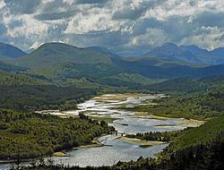
Loch Garry, (Scottish Gaelic: Loch Garraidh), is a freshwater Loch 25 km north of Fort William, Lochaber, Scotland. Loch Garry is 11 km long and 50 m deep. It is fed by waters from Loch Quoich 10 km upstream on the River Garry, and drains into Loch Oich in the Great Glen just 5 km downstream. Loch Garry is much photographed from the A87 for its romantic setting and also because a quirk of perspective makes it appear like a map of Scotland.
Contents
Map of Loch Garry, Invergarry, UK
Both lochs have been dammed for hydro-electric, the dam on Loch Quoich being the largest rockfill dam in Scotland at 320 m long and 38 m high. Water is fed by tunnel to the two power stations each producing 20MW, and the scheme was completed in 1962.
The Glen used to be home of the Clan MacDonnell of Glengarry, but since the Highland Clearances the population has been reduced to a handful of estates. The main activities are deerstalking and forestry, with little tourism apart from munro-baggers seeking some spectacularly remote mountains at the head of the glen. The lonely road along the north side of Loch Garry continues past Loch Quoich to Kinlochhourn from where a footpath continues to Knoydart.
There is another Loch Garry in Glengarry County, Ontario, Canada. This loch is named by Clan MacDonnell of Glengarry, after their previous home loch, Loch Garry in Scotland, after their emigration to the county from Scotland in result of the Highland Clearances.