
 | ||
Loaita Island 10°40′N 114°25′E, also known as Tagalog: Kota Island, Chinese: 南鑰島; pinyin: Nanyue Dao, and Vietnamese: Đảo Loại Ta, with an area of 6.45 hectares (15.9 acres), is the tenth largest of the Spratly Islands, and the fifth largest of the Philippine-occupied islands. It is located just to the west of the northern part of Dangerous Ground, and is 22 miles (35 km) southeast of Philippine-occupied Thitu Island (Pagasa Island) and 22 miles (35 km) north-northeast of Taiwan-occupied Itu Aba Island.
Contents
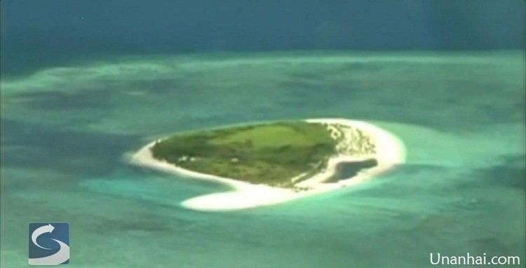
Map of Loaita Island
The island is administered by the Philippines as part of Kalayaan, Palawan. Kota is a Philippine word for a fort.
The island is also claimed by the People's Republic of China, the Republic of China (Taiwan) and Vietnam.
Environment
Loaita Island fringes the Loaita Bank, shoals and reefs. Its calcarenite outcrop is visible along its western side at low tide. The present shape of the island indicates sand buildup along its eastern side. The anchor-shaped side will eventually connect with the northern portion as the sand buildup continues, thereby creating another mini-lagoon in the process. The presence of migrating sea birds adds to the high phosphorus content of the island's sand. Occasionally, giant sea turtles lay their eggs on the island. The island is covered with mangrove bushes, above which rise coconut palms and other small trees.
Philippine Occupation
Several Philippine soldiers have been stationed on the island since 1968 when the Philippines occupied it. There are only a few structures, which serve as shelters for the soldiers.
The soldiers also guard the nearby Lankiam Cay (Panata Island) which lies about 8 miles (13 km) to the east-northeast. The cay is under observation from a tall structure on the island, and they also regularly visit it.
Loaita Nan and Loaita Cay, which are distinct from Kota Island, lie 5 miles (8 km) northwest and 1.5 miles (2 km) east-northeast. These are unoccupied features, but are also largely controlled by the Philippines.