
Country Wales Police Dyfed-Powys | Sovereign state United Kingdom Postcode district SA43 Dialling code 01239 | |
 | ||
Llantood (formerly Llantyd, Llantwyd or Llan-Illtyd) is a hamlet and parish in Cilgerran community, north Pembrokeshire, Wales.
Contents
- Map of Llantood Cardigan UK
- Location
- History
- Existing historic buildings
- Sustainable development
- References
Map of Llantood, Cardigan, UK
Location
Llantood is 3 miles (4.8 km) south-west of Cardigan on the A487 Cardigan to Newport road near the north Pembrokeshire coast. It consists of a few houses, farms and a parish church on an open hill agricultural area averaging 150 metres (490 ft) above sea level. Nearby settlements include Bridell, Glanrhyd, Monington, Pontgarreg and Tygwyn.
History
Evidence of prehistoric occupation can be seen by the remains of fortifications at Penralltddu, a scheduled monument, and at Castell Felinganol (or Castellfelorganol).
The name of the hamlet is assumed to derive from the 5th century saint, Illtyd, to whom the parish church is now dedicated. Church records date back to 1674, and the parish was in the Hundred of Kilgerran (formed in 1536) even though it was in the Cemais administrative area. The region was occupied by the Normans in the 12th century, who built castles at several strategic locations in the area; the clear remains of a motte and bailey exists at Castell Penyrallt (or Castell Pen-yr-allt). A clergyman in 1864 remembered stonework on the latter, but this was no longer evident at the time of the 1925 Royal Commission. The Norman structure may have reused a prehistoric fort.
The name of the parish church was Langetot in the Taxatio of 1293 and as Langettod in the St David's episcopal register of 1513. The attachment to St Illtyd may therefore be of later origin.
In 1870, Llantwyd was listed in Wilson's Gazetteer as consisting of 1,792 acres (725 ha), 61 houses and a population of 264.
Existing historic buildings
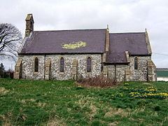
The present parish church of St Illtud dates from 1884, replacing an earlier church of 1820. Stones in the porch suggest there was a church as far back as the 13th century.
Tredefaid is a Grade II listed farmhouse, dating back to the 17th century or earlier. It was originally the home of the Lewes family, and later the Bowen family.
Penralltddu is a Victorian farmhouse built for J. W. Bowen in 1861 on the site of an earlier house dating back at least to 1773.
Sustainable development
A development of six sustainable homes at Glanrhyd was approved by the Pembrokeshire Coast National Park's planning committee in June 2014. The buildings will be manufactured locally and will include free solar powered electricity.