
Length 164 km | Country Australia | |
 | ||
River mouth Gulf St Vincent0 m (0 ft) | ||
The Light River, commonly called the River Light, is a seasonal but significant river in the Mid North region of South Australia. The catchment is a key watershed in the northern Mount Lofty Ranges.
Contents
Map of Light River, South Australia, Australia
Course
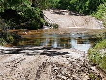
With a length of 164 kilometres, the Light River rises at an elevation of 449m near Waterloo township. It then trends southward through the localities of Steelton, Marrabel, Hamilton, and Hansborough. Here, about halfway through its course, it curves to trend westerly past Kapunda, Linwood, Hamley Bridge, Mallala, and Lower Light. It then enters Gulf St Vincent through a mangrove estuary.
Tributaries
The Light River has an expansive catchment within mainly undulating hills, much cleared since European settlement for farming and grazing purposes. There are no geological features that would permit a significant dam or reservoir. The noteworthy tributaries, by descending elevation, are Tothill Creek, Julia Creek, Pine Creek, St Kitts Creek, and the Gilbert River. The latter is a major tributary, merging into the Light River just below Hamley Bridge.
History
The indigenous name for the river is Yarralinka. The upper half of the Light River lies within the traditional lands of the indigenous Ngadjuri people of the Mid North, while much of the lower half is within the territory of the Kaurna people of the Adelaide Plains.
It is uncertain as to which European discovered and named the river. It was probably the exploration party of John Hill, William Wood, Charles Willis, and John Oakden, which left Adelaide on 1 March 1838 bound for the Murray River. Hill had accompanied William Light on his expedition of December 1837 when he discovered the Barossa Valley. Whoever was the discoverer there is no doubt that it was named after William Light.
The first township planned on the River Light was Victoria, located near present Hamilton. At great expense the Secondary Towns Association in London took out the River Light Special Survey on 3 December 1841, through their Adelaide agents John Morphett and John Hill. This speculative venture was doomed when the following year copper ore was discovered nearby, giving rise to Kapunda. Today, Victoria is a quiet farming locality.
Reputation
In the late 1840s and early 1850s when bullock teamsters carted ore from the Burra copper mines to Adelaide the upper reaches above Hamilton were commonly known by them as The Dirty Light, gaining this unflattering epithet from the deep mud they encountered in crossing it. This name then became ordinarily accepted for several decades thereafter, even by the government of the day.
The lower reaches are normally quiet, with peaceful chains of ponds in summer. However, at any time a thunderstorm in the large catchment can engender a severe flash flood. In the pioneering era, before bridges were built, these often caused drowning fatalities.